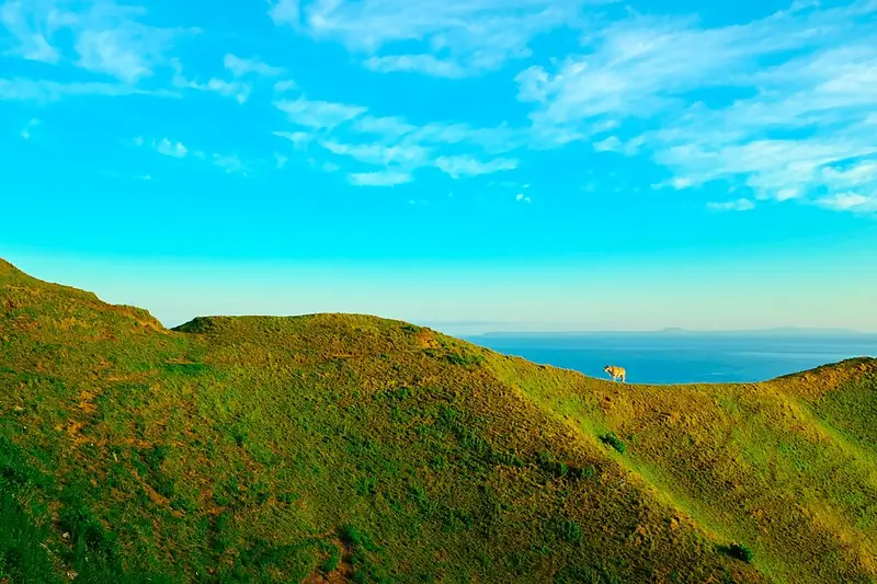
Green rolling hills of Vayang above the sea, North Batan
Photo: Jeremy.alinea · CC BY-SA 4.0 · Wikimedia Commons
Map

Batanes

Cagayan Valley
Luzon
Capital Basco
Population (2024) 18,937
Area 219 km²
Municipalities 6
Cities 0
Island Group Luzon
Languages Ivatan, Ilocano

Population: 2024 census (PSA). Area: land area.

Kapitbahay — Neighboring Provinces
An island province — the sea is the only neighbor. That isolation shaped everything here.

Batanes is the northernmost province of the Philippines, a group of islands in the Luzon Strait between Luzon and Taiwan. It is the smallest province in the country by both land area and population, and one of the most isolated. The islands sit directly in the path of Pacific typhoons, and everything about life here has been shaped by that fact.

BascoCapital
219 km²Area
6Municipalities
LuzonIsland Group

Basco, on the main island of Batan, is a small capital of stone houses, a lighthouse, and a harbor facing the South China Sea. The town is quiet in a way that reflects both its isolation and the culture of the Ivatan, whose ancestors arrived about 4,000 years ago.

★
Closest to Taiwan

Batanes lies about 190 kilometers south of Taiwan, much closer than Manila. The Ivatan language's closest relative is Yami, spoken by the Tao people of Taiwan's Orchid Island, and in June 2026 the Tao sailed a traditional boat to Batanes for the first time in more than 300 years.

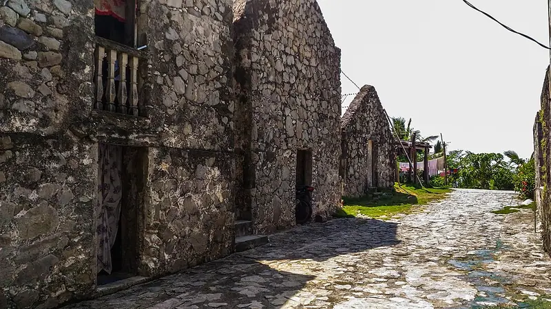
The Ivatan stone houses — built of limestone and coral with thick cogon grass roofs, designed to withstand typhoons — are the signature image of Batanes. They represent a practical architecture evolved over centuries of living with extreme weather.

The 2024 census counted 18,937 people in Batanes, which makes it the smallest Philippine province by both population and land area. Its six municipalities lie about 162 kilometers north of the Luzon mainland and about 190 kilometers south of Taiwan. The Balintang Channel separates it from the Babuyan Islands of Cagayan, and the Bashi Channel from Taiwan. In 2001 Republic Act No. 8991 declared the whole island group a protected area, the Batanes Protected Landscapes and Seascapes.
The ancestors of the Ivatan arrived about 4,000 years ago, part of the Austronesian expansion. They lived in fortified hilltop settlements called idjang and traded on the Maritime Jade Road. Their language is closest to Yami on Taiwan's Orchid Island, but it belongs to the Malayo-Polynesian languages, not the Formosan languages of Taiwan. The islands' isolation preserved a distinct culture that Spanish rule only partly changed.

c. 2000 BCE

Austronesian Settlement

The ancestors of the Ivatan arrived about 4,000 years ago during the Austronesian expansion. They lived in fortified hilltop settlements called idjang, farmed, built boats and used gold as currency. Batanes was a major site on the Maritime Jade Road, a sea trade in jade that ran from about 2000 BCE to 1000 CE.

1687

Dampier's Visit

The English explorer William Dampier spent August and September 1687 in the islands. He named Itbayat "Orange Isle", Batan "Grafton Isle" and Sabtang "Monmouth Isle", and described the fortified hilltop settlements and the islanders' crops and livestock.

1783

Spanish Annexation

Spain claimed Batanes in 1783 under Governor-General José Basco y Vargas, partly to keep the islands from British ships using the Bashi Channel, and governed it as part of Cagayan. Basco and Ivana were the first towns.

1790

Revolt of Aman Dangat

When the Spanish ordered the Ivatan to leave their idjang and live in the lowlands, local leaders led by Aman Dangat revolted. The Spanish put down the revolt, killing Aman Dangat and other leaders.

1907–1909

Becomes a Province

Batanes became a sub-province of Cagayan on 20 August 1907 under Act No. 1693, and an independent province on 20 May 1909 under Act No. 1952.

8 December 1941

Japanese Landing

A Japanese task force from Taiwan landed on Batan on the morning of 8 December 1941 and took the airfield outside Basco, making it the first American territory occupied by Japan. Filipino troops liberated the islands in early 1945.

1993

UNESCO Tentative List

The Batanes Protected Landscape and Seascape, covering the whole province, was placed on the Philippines' tentative list for UNESCO World Heritage inscription.

June 2026

Voyage from Orchid Island

The Tao people of Taiwan's Orchid Island made their first traditional ocean voyage in more than 300 years to meet the Ivatan of Batanes.

Batanes was placed on the UNESCO World Heritage tentative list in 1993 for its protected landscape and seascape — the combination of stone architecture, traditional land use and the natural environment of the islands.

Ivatan culture is organized around the family, the community, and the management of a difficult environment. The vakul, the traditional headgear worn by Ivatan women while working in the fields, is a sign of Ivatan practical ingenuity. It protects the wearer from both sun and rain.

Stone Architecture

Ivatan stone houses are built of limestone and coral, a method that spread after the Spanish introduced lime production on a large scale. The roof is a deep cogon grass thatch that insulates and sheds water. The design — low profile, small windows, massive walls — is designed to survive the typhoons that regularly hit Batanes. Some old houses, such as those of the Sinadumparan type, are among the oldest buildings in the islands.

★
The Tatala

Ivatan fishermen traditionally navigated using the tatala — a traditional boat designed for the rough seas of the Luzon Strait. Fishing in Batanes requires departing in early morning when seas are calmer and returning before afternoon swells build. The channels around Batanes are known for strong currents and rough seas.

Community Labor

Communal labor shared among families for farming, building and other large tasks reflects the practical need for cooperation in a small island community. The tradition has continued into contemporary life, particularly for house construction and agricultural clearing.

See the great festivals in Pista ng Pilipinas →

Ivatan food is shaped by isolation and weather. The islands cannot import fresh ingredients reliably, and months of rough seas can cut the supply line from Luzon. The traditional diet is built around what can be grown, caught, or preserved on the islands — root crops, fresh fish, and dried or fermented stores for typhoon season.

Uvud Balls

Balls made from the pith of the banana trunk — uvud — mixed with minced pork or fish, shaped, and simmered in a light broth. The banana trunk pith has a texture somewhere between firm tofu and young jackfruit. It is one of the most distinctively Ivatan preparations.

Dibang (Flying Fish)

Flying fish caught in the Luzon Strait, dried and grilled. Dibang season runs from March to June, when the fish migrate through the strait. During this period, flying fish appears fresh daily in Basco market. Outside the season, dried dibang is available year-round.

Vunung (Ivatan Pork and Vegetable Stew)

Batanes
20 minutesPrep
50 minutesCook
4-6Serves
Ingredients
  • 500g, cubedpork belly or ribs
  • 3 medium tubers, peeled and cubedgabi (taro)
  • 2 medium, cubedsweet potato (camote)
  • 1 medium, slicedbanana blossom
  • 4 cloves, mincedgarlic
  • 1 medium, slicedonion
  • 1-inch knob, slicedginger
  • to tastesalt
  • 5 cupswater
Method
  1. Sauté garlic, onion, and ginger. Add pork and brown on all sides.
  2. Add water and bring to a boil. Skim the foam.
  3. Add taro and sweet potato. Simmer for 20 minutes until beginning to soften.
  4. Add banana blossom. Season with salt.
  5. Cook for another 15–20 minutes until pork is tender and root vegetables are fully cooked.
  6. The stew should be brothier than a stew and thicker than a soup. Serve with rice.
Cook's note

Gabi must be fully cooked — undercooked taro causes throat irritation. The sweet potato and gabi will naturally thicken the broth as they break down.

Ivatan is the language of the Batanes islands. Although the islands are closer to Taiwan than to Luzon, it is not a Formosan language. It belongs to the Batanic (Bashiic) group, possibly a primary branch of the Malayo-Polynesian languages, and its closest relatives are Itbayaten and Yami, spoken by the Tao of Taiwan's Orchid Island. Ilocano is also spoken, brought by settlers who came during the Spanish period.

IvatanPrimary
Ivasay (north), Isamurung (south)Dialects
Itbayaten, IlocanoAlso
Filipino, EnglishOfficial
★
Orchid Island Connection

Ivatan's closest relatives are Itbayaten and Yami, the language of the Tao people of Orchid Island off Taiwan. Together they form the Batanic group, which linguists place among the Malayo-Polynesian languages, not the Formosan languages of Taiwan's other indigenous peoples. In June 2026, the Tao sailed a traditional boat to Batanes to meet the Ivatan, their first such voyage in more than 300 years.

Filipino and English are taught in schools and used in government. Many Ivatans also speak Ilocano, and Tagalog is widely understood.

Ivatan has two dialects: Ivasay, spoken in Basco and the northern half of Batan, and Isamurung, spoken in the south of Batan (Mahatao, Ivana, Uyugan) and on Sabtang. Where Ivasay speakers say t, Isamurung speakers often say ch. Itbayat, the largest island by area, has its own closely related speech, Itbayaten.

Batanes is one of the most sought-after provincial destinations in the Philippines, with a reputation that exceeds its infrastructure. Getting there requires advance planning, weather flexibility, and a tolerance for cancelled flights. Once arrived, the landscape is unlike anything else in the country.

Basco Airport (BSO)Airport
~2 hrs by air; no regular passenger ferry from ManilaFrom Manila
February to May (calmer weather)Best Season
June–October; flights often cancelledTyphoon Risk
Stone houses of Chavayan Village, Sabtang Island
Photo: Jeremy.alinea · CC BY-SA 4.0 · Wikimedia Commons

Sabtang Island

The most traditionally preserved island in Batanes, reached by a 30-minute bangka ride from Batan in good weather. The stone villages of Savidug and Chavayan keep many traditional houses. Overnight homestays in stone houses are available.

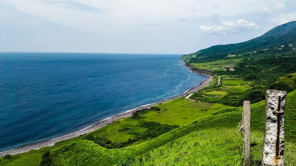
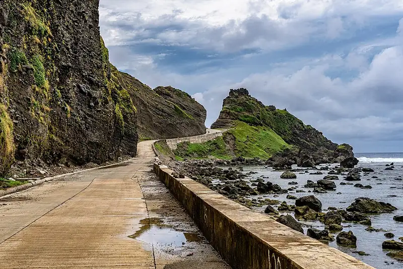
The coastal road climbing toward the Alapad hills and rock formations, Batan Island
Photo: Regino Ferino · CC BY-SA 4.0 · Wikimedia Commons

Batan Island Coastal Road

The road circling Batan Island passes through Basco, several traditional villages, the Naidi Hills, and along coastal cliffs above the South China Sea. Renting a scooter and doing the circuit at your own pace is the standard way to see the island. Rolling green hills, stone walls, and ocean views throughout.

Vayang Rolling Hills on a bright day
Photo: Johnkevinreglos · CC BY-SA 4.0 · Wikimedia Commons

Vayang Rolling Hills

Grassland hills in the western part of Batan Island, shaped by centuries of grazing and the constant wind. The hills slope toward sea cliffs with the South China Sea below. On clear days, Itbayat Island is visible to the north.

◆
Weather Dependency

Batanes travel is hostage to weather. Flights are regularly cancelled due to fog, wind, and typhoons. Build at least two buffer days into your schedule. Do not have a flight home the day after your Batanes flight is scheduled to land.

The whole province has been a protected area since 2001, when Republic Act No. 8991 established the Batanes Protected Landscapes and Seascapes and made the surrounding waters a buffer zone. On land, the north of Batan is dominated by Mount Iraya, a 1,009-meter active volcano that last erupted in 1454, and the south by the older Mount Matarem. Grassy hills, stone walls and the payaman (communal pastures) make up much of the landscape. Offshore, the reefs are rich in marine life, and DENR rangers have found several green sea turtle nesting beaches, including a new one on the Sabtang coast in June 2026.

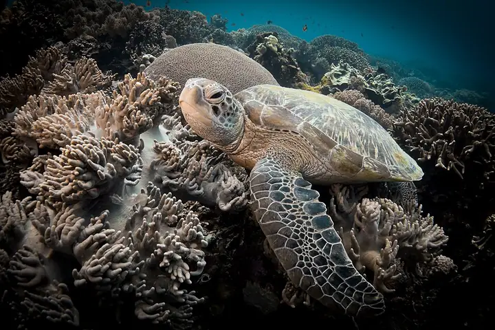
A green sea turtle over coral at Apo Island
Photo: Anna Varona · CC BY 4.0 · Wikimedia Commons
Green Sea Turtle
Chelonia mydas
Endangered
A large sea turtle that grazes on seagrass. It nests on several Batanes beaches, which DENR rangers guard and net off to protect the eggs.
Field note: Keep away from nesting beaches at night and never buy turtle products.
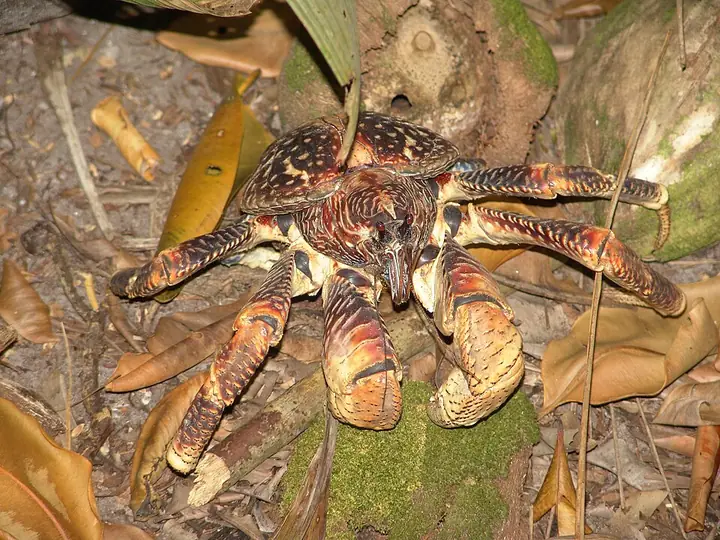
A coconut crab
Photo: Drew Avery · CC BY 2.0 · Wikimedia Commons
Coconut Crab
Birgus latro
Vulnerable
Considered the largest land crab in the world, it is called tatus in Batanes. It was once a popular local delicacy, but it is now a threatened species in the Philippines.
Field note: Do not order or buy tatus; buying, gathering or transporting it is prohibited.
Meet all 65 Philippine animals in Hayop ng Pilipinas →

The Houses That Stay

The stone houses of Batanes are built of limestone and coral, with roofs of thick cogon grass. Their walls are heavy, their windows small and their profile low. The method grew after the Spanish introduced lime production on a large scale, and some of the old houses of the Sinadumparan type are among the oldest buildings in the islands. When a typhoon comes, families add wood to the openings and tie down the roofs with nets and ropes.

The Ivatan read the weather from the land around them. When the cattle leave the communal pasture, the payaman, to find shelter, and when birds take refuge in houses or on the ground, families gather their animals and stay indoors. Life in the islands has long been planned around the storms that cross the Luzon Strait.

Not every village survived. On Batan, the ghost village of Songsong is a cluster of roofless stone shells, abandoned after a tidal wave hit the island in the 1950s. Today, visitors walk among its walls. The houses elsewhere still stand, and many are still lived in.

Sources · updated 4 October 2026
Photo credits (6)

Photos from Wikimedia Commons, used under the licences shown; some were resized. All photo credits