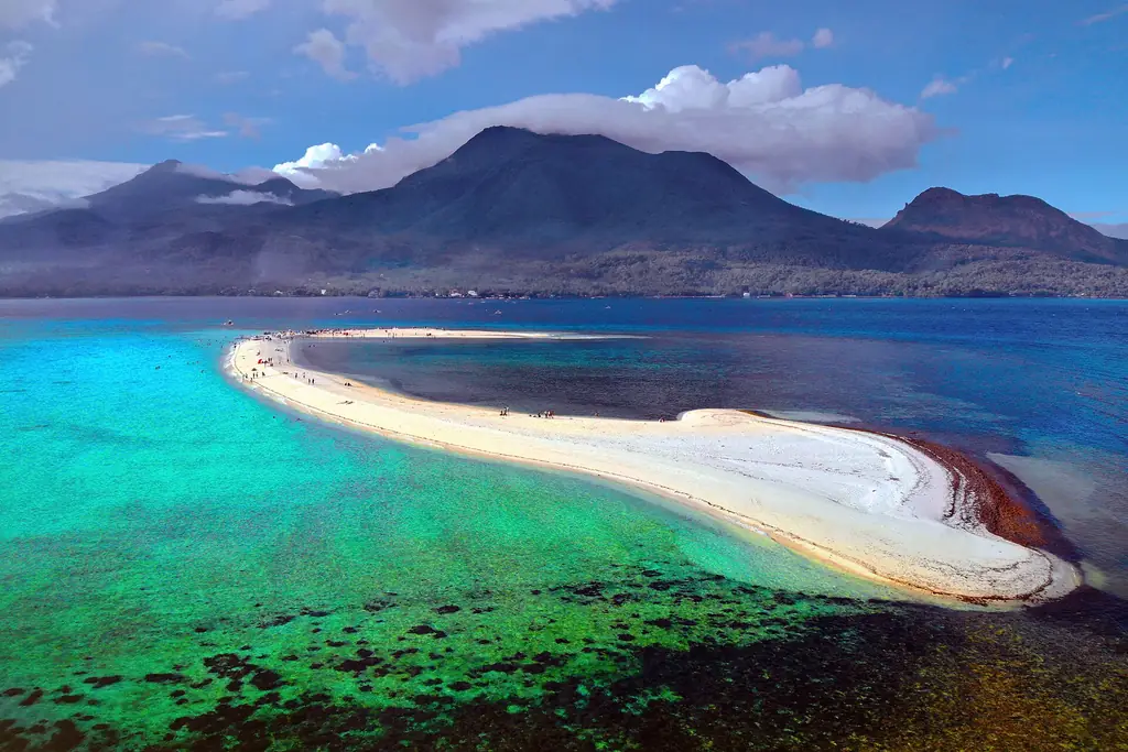
White Island sandbar in turquoise water with Camiguin's volcanoes behind
Photo: Allan Jay Quesada · CC BY-SA 4.0 · Wikimedia Commons
Map

Camiguin

Northern Mindanao
Mindanao
Capital Mambajao
Population (2024) 94,892
Area 238 km²
Municipalities 5
Cities 0
Island Group Mindanao
Languages Cebuano, Filipino

Population: 2024 census (PSA). Area: land area.

Kapitbahay — Neighboring Provinces
An island province — the sea is the only neighbor. That isolation shaped everything here.

Camiguin is a small island province in Northern Mindanao, located in the Bohol Sea north of Cagayan de Oro. It is shaped by its volcanoes, four stratovolcanoes and their many domes, standing on an island of only 238 square kilometers. The landscape is dramatic: steep volcanic slopes descending to narrow coastal strips, with cold springs, waterfalls, and a submerged cemetery among its defining features.

MambajaoCapital
238 km²Area
5Municipalities
MindanaoIsland Group
Northern Mindanao (X)Region

The Island Born of Fire

The volcanoes form the island's interior spine: Hibok-Hibok, with its young side cone Mount Vulcan and flank domes such as the Tres Marias Hills; Mount Timpoong, whose Timpoong Peak, at 1,614 meters, is the island's highest point, alongside the peak of Mambajao; Mount Butay; and Mount Guinsiliban in the south. Hibok-Hibok is the only one with historical eruptions; its deadliest, on 4 December 1951, killed more than 3,000 people, and its last was in 1953. The volcanic activity that makes the island dangerous also makes it fertile and beautiful: the slopes support lush vegetation and the island's cold springs are fed by rainwater percolating through volcanic rock.

★
Did You Know?

Camiguin's tourism tagline is 'Island Born of Fire' — appropriate given that the entire island is volcanic in origin and still geologically active.

The province has five municipalities: Mambajao (the capital), Catarman, Sagay, Mahinog, and Guinsiliban. The island circumference is roughly 64 kilometers, making it possible to drive the entire coastal road in about two hours under normal conditions. The population is about 95,000 (2024 census), small enough that a visitor asking for directions to any attraction will be met with personal knowledge rather than vague gestures.

The 2024 census counted 94,892 people on Camiguin, making it the second-smallest province in the country in both population and land area, after Batanes. Mambajao, the capital, is also its largest town in area and population. The island is about 23 kilometers long and 14.5 kilometers wide and lies some 10 kilometers off the northern coast of mainland Mindanao. Its name is said to come from kamagong, a kind of ebony tree that grows near Lake Mainit in Surigao del Norte, the homeland of the Manobo who are believed to have been its first settlers. Fishing and farming are the main livelihoods: copra brings in the most income, lanzones is the island's signature crop, and tourism has grown steadily. Camiguin has three National Cultural Treasures, the Old Bonbon Church ruins and the Sunken Cemetery in Catarman and the Spanish-era watchtower of Guinsiliban.
Camiguin was inhabited before Spanish contact, with communities living on the coastal margins of the volcanic island. The Spaniards founded their first settlement, at Guinsiliban, in 1598, and the island was administered as part of the province of Misamis before being separated as its own province in the 20th century.

1521–1598

First Spanish Contact

Old Spanish documents say that Ferdinand Magellan in 1521 and Miguel López de Legazpi in 1565 stopped at Camiguin. The first Spanish settlement was founded in 1598 at what is now Guinsiliban, whose name comes from a Kinamiguin word meaning to look out for pirates from a watchtower; the old Spanish watchtower still stands.

1679

Catarman Founded

The first major Spanish settlement on the island, Katagman or Catarman, was founded in 1679 at what is now Barangay Bonbon. The census of 1818 recorded 1,653 native families on Camiguin.

1871–1875

Birth of Mount Vulcan

Earthquakes began on 16 February 1871, and on 30 April a fissure opened just southwest of Catarman. Mount Vulcan grew from it over the next four years, pouring lava into the sea and destroying the town; part of Bonbon sank, carrying the town cemetery below sea level. The Challenger expedition saw the new dome still smoking in 1875.

1901

Battle of Catarman

During the Philippine–American War, American soldiers landed on Camiguin to take control of the island. Camiguinons armed with bolos and spears, led by Valero Camaro, fought them in a short battle in Catarman, in which Camaro was shot and killed.

4 December 1951

Hibok-Hibok Eruption

After three years of unrest, including a 1949 eruption that killed 79 people, Mount Hibok-Hibok erupted with pyroclastic flows and poisonous gases that devastated nearly 19 square kilometers, especially around Mambajao. More than 3,000 people were killed, and the island's population fell from about 69,000 to about 34,000 as survivors moved to mainland Mindanao.

1957–1966

From Sub-province to Province

Camiguin had been part of Misamis Oriental since 1930. Republic Act No. 2021 of 22 June 1957 made it a sub-province, and Republic Act No. 4669 of 18 June 1966 made it a separate province.

7 November 2001

Typhoon Nanang

Before dawn, Tropical Storm Lingling, locally named Nanang, dropped torrential rain on Camiguin's mountains and set off massive mudslides that killed about 200 people, most of whom were never found.

The province recovered slowly from the 1951 eruption. In subsequent decades it developed a reputation as a quiet, scenic destination, and modern tourism infrastructure has grown steadily since the 1990s while preserving much of the island's unhurried character.

Camiguin's cultural life is marked by its small-island intimacy and its strong Cebuano identity. The province is part of Northern Mindanao but shares the language and many cultural practices of the Visayas. The Lanzones Festival, held every October, is the primary annual celebration — a harvest festival for the island's famous lanzones fruit.

Lanzones Festival

Camiguin lanzones — a small, sweet, translucent-fleshed fruit — are considered the finest in the Philippines. Their quality is attributed to the volcanic soil. The Lanzones Festival in October celebrates the harvest with street dancing, cultural presentations, and the crowning of a festival queen. The event transforms the island's normally quiet streets and is the biggest tourism draw of the year.

★
Not Bitter in Camiguin

Lanzones fruit grown elsewhere in the Philippines can be mildly bitter. Camiguin lanzones are consistently sweet, a characteristic attributed to the island's volcanic soil. Even within the island, lanzones from different slopes can have noticeably different flavor profiles.

The Sunken Cemetery and the ruins of Old Catarman town hold a particular place in local memory. Every All Souls' Day (November 2), boats carry flowers and candles to be placed over the submerged graves — a practice that combines Catholic tradition with a landscape unlike any cemetery in the Philippines.

See the great festivals in Pista ng Pilipinas →

Camiguin's food follows the Cebuano-Mindanao tradition — grilled seafood, coconut-based dishes, and the abundant fruit that the volcanic soil produces. The island's small size means freshness is not a marketing claim: most seafood served on the island was in the water that morning.

Camiguin Lanzones

Not a cooked dish but the island's most important food product. Eaten raw, peeled by pressing the segments apart to reveal the white translucent flesh. At peak harvest in October, roadside sellers offer piles of fresh lanzones. Locally the fruit is called buahan, and since lanzones became the island's main crop it has given its name to the Lanzones Festival, held in Mambajao in the third week of October.

Grilled Panga ng Tuna

Tuna jaw grilled over charcoal — a staple across Mindanao that is particularly good in Camiguin where the fish is genuinely fresh. Served with calamansi, soy sauce, and spiced vinegar. Cheap, abundant, and among the best uses of tuna available in the Philippines.

Sinugba (Cebuano-Style Grilled Pork Belly)

Camiguin / Cebuano tradition
30 minutes (plus 2 hours marinade)Prep
20 minutesCook
4Serves
Ingredients
  • 800g, cut into slabsPork belly, skin on
  • 3 tablespoonsBanana ketchup
  • 3 tablespoonsSoy sauce
  • 3 tablespoonsCalamansi juice
  • 1 tablespoonBrown sugar
  • 6 cloves, mincedGarlic
  • to tasteSalt and pepper
Method
  1. Combine all marinade ingredients. Score the pork belly skin lightly.
  2. Coat pork in marinade. Refrigerate at least 2 hours, preferably overnight.
  3. Prepare charcoal grill. Grill pork over medium-high heat, turning every few minutes, until skin is crisp and charred in patches and meat is cooked through — about 20 minutes total.
  4. Rest 5 minutes before slicing into portions.
  5. Serve with spiced vinegar (sukang maasim with garlic and chili) and steamed rice.
Cook's note

Charcoal is non-negotiable for sinugba — gas grilling produces an inferior result. The banana ketchup in the marinade adds a slight sweetness and helps the skin caramelize. Do not rush over high heat or the outside will burn before the inside cooks.

✦
Buy Direct

During lanzones season (October), buy fruit directly from roadside sellers along the circumferential road rather than at the Mambajao market. Prices are lower and the fruit is fresher off the tree.

Cebuano is the primary language of Camiguin. Though the province is administratively in Northern Mindanao, its linguistic and cultural connections are with the Visayas — specifically with the Cebuano-speaking world that stretches from Cebu through Bohol and across much of Mindanao. The Cebuano spoken in Camiguin has some local vocabulary reflecting the island's specific culture and environment.

CebuanoPrimary language
Austronesian, Visayan branchLanguage family
Kinamiguin (Manobo), Filipino, EnglishOther languages

The small size of the island creates a linguistic community with unusual cohesion — most people know most other people, and this familiarity shapes communication. Cebuano is now spoken across all five municipalities, but it is not the island's oldest language: Kinamiguin, a Manobo language, is still spoken by a few people in Sagay and Guinsiliban.

Kinamiguin, also called Kamigin, is the northernmost of the Manobo languages, which points to the island's first settlers having come from the Lake Mainit area of Surigao del Norte; the 2000 census counted about 27,000 speakers, but it is declining as most islanders have shifted to Cebuano. Other languages heard on the island include the Boholano variety of Cebuano, Hiligaynon, Ilocano, Kapampangan and Waray, and Tagalog and English are widely spoken and understood.

Camiguin is reached by ferry from Balingoan port in Misamis Oriental, about two hours by bus from Cagayan de Oro's Agora terminal, to Benoni port on the island's southeastern side. The crossing takes just over an hour, and boats run from about 4 a.m. to 5 p.m. There is also a ferry connection from Cagayan de Oro to Camiguin. The island is small enough to circumnavigate by motorcycle in a half day.

~2 hrs by bus + 1 hr ferryFrom CDO
Just over 1 hr to BenoniFerry from Balingoan
Motorbike rental (recommended)Getting around
March–May, October (Lanzones)Best months
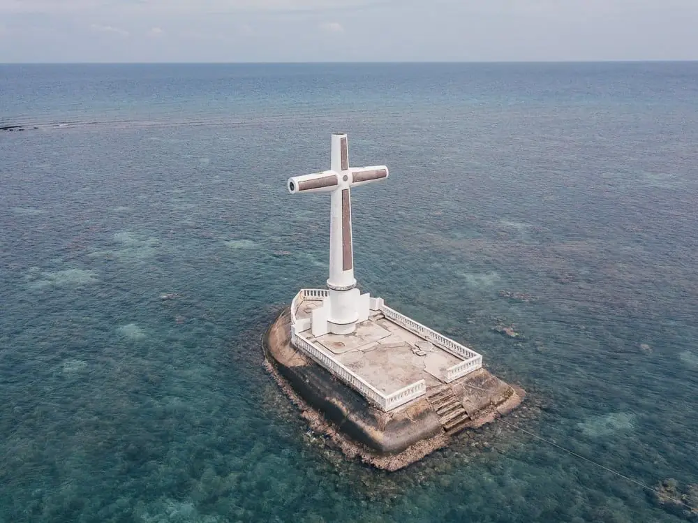
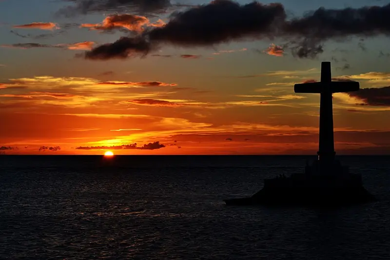
The cross marking the Sunken Cemetery against a sunset sky
Photo: Edwin Juen Jr. · CC BY-SA 4.0 · Wikimedia Commons

Sunken Cemetery

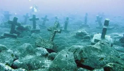
The cemetery of old Catarman town, submerged after the 1871 volcanic activity shifted the coastline. A large white cross marks the site in shallow water offshore. Boats can be hired to visit the cross; snorkelers can see the submerged graves below. On All Souls' Day, this becomes a site of candlelit remembrance with flowers placed on the water.

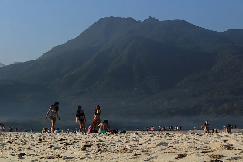
The curving white sandbar of White Island with Camiguin's mountains behind
Photo: Wilborne Ian Lustre · CC BY-SA 4.0 · Wikimedia Commons

White Island

A pure white sand bar north of Mambajao, shifting in position and size with the tides and seasons. The sand bar is uninhabited and has no facilities. Boats from Yumbing Beach bring visitors out for the day. The view back to the island's volcanic mountains from White Island is among the most photographed in the Philippines.

Ardent Hot Spring

Natural hot spring pools fed by geothermal activity at the foot of Mount Hibok-Hibok in the municipality of Mambajao. The water is genuinely hot — around 40°C — and the setting, surrounded by forest, is peaceful. Most commonly visited in the early morning before day-trippers arrive.

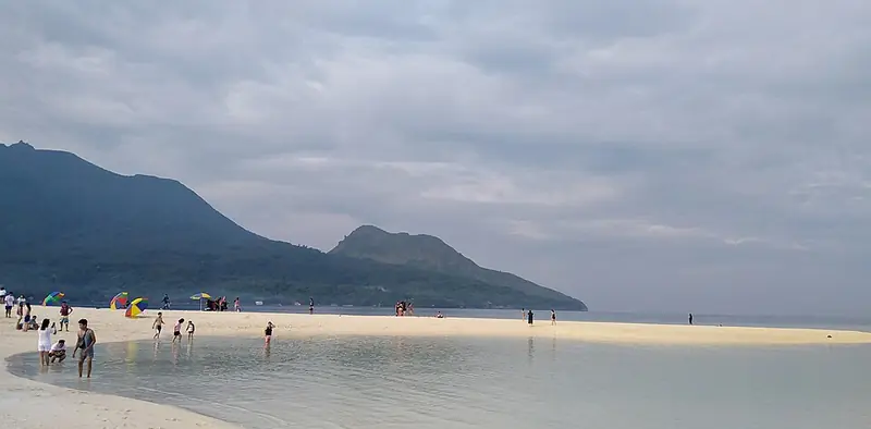
Mount Hibok-Hibok seen from the beach on White Island
Photo: Elmer nev valenzuela · CC BY-SA 4.0 · Wikimedia Commons

Mount Hibok-Hibok

Camiguin's most active volcano, 1,332 meters high; the island's highest point is Timpoong Peak, at 1,614 meters. Trekking to the summit takes 6–8 hours round trip and requires registration with the Philippine Institute of Volcanology and Seismology. The trail passes through several vegetation zones and offers views of the Bohol Sea. The volcano is closely monitored; check alert levels before planning the climb.

Camiguin is a young volcanic island, and its only remaining forest covers the mountain core of Hibok-Hibok and Timpoong. In 2004 Proclamation No. 570 made that core the Timpoong and Hibok-Hibok Natural Monument, protecting the island's main watershed, and the forests of the Mount Hibok-Hibok Protected Landscape have been declared an ASEAN Heritage Park. For a small island the forest is remarkable: at least six vertebrates are believed to be found nowhere else, among them the Camiguin hawk-owl, the Camiguin hanging parrot, the Camiguin forest mouse, the Camiguin forest rat and the Camiguin narrow-mouthed frog. All depend on the forest that survives on the volcanoes' upper slopes, threatened by logging, clearing for farms and the growth of tourism. Offshore, the giant clam sanctuary run by the Kabila Giant Clam Conservation and Ocean Nursery holds seven of the nine giant clam species, and the reefs around White Island and the Sunken Cemetery are popular for snorkeling.

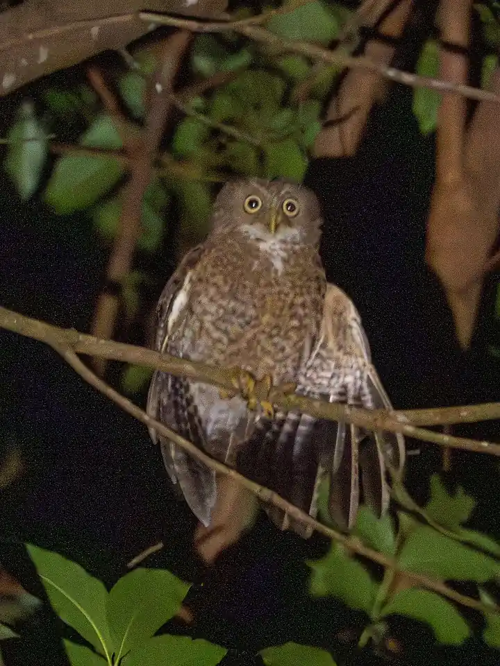
A Camiguin boobook perched at night (photographed on Camiguin)
Photo: Chetatata · CC BY-SA 4.0 · Wikimedia Commons
Camiguin Hawk-Owl
Ninox leventisi
Vulnerable
Also called the Camiguin boobook, it is found only on Camiguin and is the only owl in the Philippines with greenish-yellow or grayish eyes. Long treated as a subspecies of the Philippine hawk-owl, it was recognized as a species in 2012 on the evidence of its voice. The IUCN estimates 250 to 999 mature birds, threatened mainly by forest clearance.
Field note: Night field work near forest may reveal its call. Avoid clearing the last forest patches, which are its only home.
Camiguin Forest Mouse
Apomys camiguinensis
Vulnerable
A small forest mouse found only on Camiguin, living in the mountain forest around the volcanoes. Because its whole range is one small island, the IUCN lists it as Vulnerable.
Giant Clams of Camiguin
Tridacna species
Critically Endangered (T. gigas)
The waters around White Island and the sunken cemetery hold giant clams and living coral. Local marine sanctuaries protect them and help reefs recover. The largest species, Tridacna gigas, has been listed as Critically Endangered by the IUCN since 2024.
Field note: Do not stand on or touch coral and clams while snorkeling. Anchor only on sand or use mooring buoys.
Meet all 65 Philippine animals in Hayop ng Pilipinas →
← All stories
Kasaysayan · Catarman

The Sunken Cemetery

Off the coast of Camiguin, a large white cross rises from the sea. It marks the Sunken Cemetery, one of the island's most haunting landmarks, and the story behind it is written in fire and water.

Before the volcanoes made it famous, Camiguin was a quiet, prosperous place. The town of Catarman thrived around the Guiob Church, a stone church built in the early 1800s. Then, in May 1871, Mount Vulcan erupted. Over the years that followed, lava buried the town, and the land along the coast, including the old cemetery, slowly sank beneath the sea.

Today the Guiob Church ruins still stand, their thick walls blackened but unbowed, and out on the water the cross keeps watch over the graves below. Snorkelers can swim above coral-covered tombstones. It is a place where history and nature meet, a memorial to a community that endured, and it is now a National Cultural Treasure.

Mga Larawan

Sources · updated 4 October 2026
Photo credits (5)

Photos from Wikimedia Commons, used under the licences shown; some were resized. All photo credits