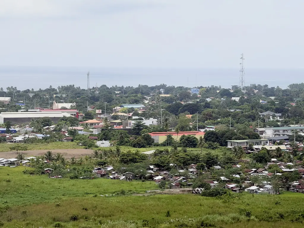
Malita town and the Davao Gulf coast seen from the national highway
Photo: General-chikuwa · CC BY-SA 4.0 · Wikimedia Commons
Map

Davao Occidental

Davao Region
Mindanao
Capital Malita
Population (2024) 317,598
Area 2,163 km²
Municipalities 5
Cities 0
Island Group Mindanao
Languages Cebuano, Kalagan, B'laan

Population: 2024 census (PSA). Area: land area.

Kapitbahay — Neighboring Provinces

Davao Occidental is one of the newest provinces in the Philippines, carved from Davao del Sur in 2013. It occupies the southern tip of the Davao Region, between the Davao Gulf and the Celebes Sea. It is a province still in the process of becoming — its institutions new, its infrastructure sparse, its coastline largely undeveloped.

MalitaCapital
2,163 km²Area
5Municipalities
MindanaoIsland Group

Malita serves as the provincial capital, a small coastal town at the mouth of the Malita River. The town has grown since provincehood was declared but remains modest — a market, a plaza, a provincial capitol building that was still completing construction years after the province was established.

★
Created in 2013

Davao Occidental was created by Republic Act 10360, signed on 14 January 2013. It became the 81st province in the Philippines. Its five municipalities — Don Marcelino, Jose Abad Santos, Malita, Santa Maria, and Sarangani — were previously part of Davao del Sur.

The province is home to significant indigenous communities — the Tagakaulo Kalagan and the B'laan among them — whose territories cover much of the interior. Remote coastline on the Davao Gulf and the Celebes Sea, rainforest, and river systems make Davao Occidental one of the least-visited and least-mapped provinces in the country.

Davao Occidental had 317,598 people in the 2024 census. Its five towns are Don Marcelino, Jose Abad Santos, Malita, Santa Maria and Sarangani; Malita, the capital, is the largest and most populous. The town of Sarangani is made up of Balut and Sarangani islands, the province's island portion. The province borders Davao del Sur, Sarangani province and the Davao Gulf.
The territory of present-day Davao Occidental was part of the broad Davao colonial district and, later, the province of Davao del Sur. It remained at the periphery of administrative attention for most of the twentieth century — distant from Davao City, poorly connected by road, and sparsely populated outside the coastal settlements.

Pre-colonial

Tagakaulo and B'laan Territories

The area was inhabited by the Tagakaulo Kalagan and B'laan peoples, who occupied the river valleys and coastal margins. These communities had trade relationships with the Maguindanao Sultanate and with coastal Sama and Badjao communities.

1936

Malita Founded

Malita was founded on 13 November 1936 by Proclamation No. 64 of President Manuel L. Quezon. It was the first town established in what is now Davao Occidental and later became its capital.

1967

Part of Davao del Sur

When the original Davao province was split into three on 8 May 1967, the municipalities in this area became part of Davao del Sur. They remained among the most isolated and underdeveloped portions of that province.

2013

Province of Davao Occidental Established

Republic Act No. 10360, passed by Congress in late 2012, was signed by President Benigno Aquino III on 14 January 2013. A plebiscite on 28 October 2013 ratified the new province, the country's 81st, made up of five towns of Davao del Sur's second district.

2016

First Elected Officials

Davao del Sur officials, assisted by the Department of the Interior and Local Government, ran the new province until its first elected officials took office on 30 June 2016.

Since 2013, the provincial government has focused on basic infrastructure — roads, electricity, connectivity — that much of the province lacked at the time of its creation. The process has been slow, constrained by terrain, budget, and the logistical difficulty of reaching communities accessible only by river or boat.

Davao Occidental's cultural identity is shaped by its indigenous communities, its fishing villages, and the relative isolation that has preserved both. The Tagakaulo Kalagan people are the dominant indigenous group of the coastal lowlands; the B'laan occupy the interior highlands.

The Tagakaulo Kalagan

The Tagakaulo are a coastal-riverine people who have historically blended Islamicized Maguindanao cultural elements with indigenous Austronesian practices. They are boat-builders and fishers, and their traditional music includes kulintang ensemble performance. Their weaving traditions produce distinctive cloth used in ceremonial contexts.

The Badjao — sea nomads — also have communities along the coast of Davao Occidental, living on or near the water in the traditional manner. Their presence points to the province's position at the edge of the broader Sulu Sea maritime world.

★
A Province at the Edge

Davao Occidental faces the Celebes Sea, which connects it culturally and historically to Borneo, the Sulu Archipelago, and the maritime trade networks that predated the Spanish by centuries. This southern orientation distinguishes it from the interior Davao provinces, whose cultural references are more exclusively Mindanao-highland.

See the great festivals in Pista ng Pilipinas →

Coastal fishing and subsistence agriculture define the food culture of Davao Occidental. The Celebes Sea provides tuna, squid, and reef fish. Inland, root crops and forest products supplement rice in communities where supply chains are unreliable.

Grilled Yellowfin Tuna

The waters off Davao Occidental are in the migratory path of yellowfin tuna. Freshly caught fish, grilled over coconut shell charcoal with minimal seasoning, is the standard preparation. The quality of the fish requires little else.

Tiyula Itum

A Tausug-influenced black soup made with beef or chicken, burned coconut, and a paste of spices including turmeric and ginger. Found in the Muslim coastal communities of southern Mindanao, including parts of Davao Occidental's coast.

Kinilaw na Tanigue

Davao Occidental coast
15 minutesPrep
0 minutes (acid-cured)Cook
4Serves
Ingredients
  • 500gtanigue (Spanish mackerel), cubed
  • ½ cupcoconut vinegar
  • 4 tbspcalamansi juice
  • 3 tbspginger, finely julienned
  • 1 smallred onion, thinly sliced
  • 2–3 piecesbird's eye chili, chopped
  • 1 tspsalt
  • 3 tbspfresh coconut milk (optional)
Method
  1. Rinse fish cubes and pat dry.
  2. Toss with coconut vinegar and let cure for 5 minutes, then drain.
  3. Add calamansi juice, ginger, onion, and chili.
  4. Season with salt and toss well.
  5. If using coconut milk, add it last for a creamier finish.
  6. Serve immediately.
Cook's note

Freshness is everything with kinilaw. The fish should be caught the same day. Coconut vinegar from local producers is less harsh than commercial cane vinegar and suits the delicate flesh of tanigue.

Cebuano is the trade and administrative language of Davao Occidental, used in markets, schools, and government. But the province has a higher proportion of indigenous-language speakers than most Davao provinces, given its relative isolation and the persistence of Tagakaulo, B'laan, and Badjao communities.

CebuanoPrimary Language
Tagakaulo, B'laan, BadjaoIndigenous Languages
AustronesianLanguage Family
Davao RegionRegion

Tagakaulo is spoken primarily along the coastal municipalities of Don Marcelino and Jose Abad Santos. It is a dialect of Kalagan, a language cluster of the Davao Gulf area.

The Badjao language — sometimes called Sama Dilaut — is spoken by sea nomad communities along the coast. It is part of the Sama-Bajaw language chain stretching across the Sulu Archipelago and into Borneo. Linguistically, it links Davao Occidental to a much wider maritime world.

Davao Occidental is a difficult province to visit without planning. Roads from Digos City or Davao City to Malita exist but are long and sometimes poor in condition. For remote municipalities like Jose Abad Santos, travel by small boat along the coast is often more practical than overland routes.

~180 km to MalitaDistance from Davao City
4–5 hours by busTravel Time
Davao–Malita via Halsema Road SouthMain Route
Francisco Bangoy International, Davao CityNearest Airport

Malita Coastline

The coast near Malita offers undeveloped beaches fronting the Celebes Sea. Without the infrastructure of more touristed areas, these beaches retain a rawness — no facilities, no signage, just the water and the shoreline. Local fishermen operate from barangays along this stretch.

Mount Busa

One of the highest peaks in Mindanao's southern mountains, Mount Busa sits on the border between Davao Occidental and South Cotabato. It is the traditional homeland of the B'laan people and a challenging climb through primary rainforest. The trail requires local guides from B'laan communities.

Jose Abad Santos

The southernmost municipality in the province and one of the most remote in Mindanao. Named after the wartime Chief Justice who was executed by Japanese forces for refusing to collaborate. The town has a fishing harbor and a quiet pace of life shaped entirely by the sea.

◆
Travel Conditions

Check current conditions with the provincial tourism office in Malita before traveling to remote barangays. Road conditions deteriorate significantly in the wet season.

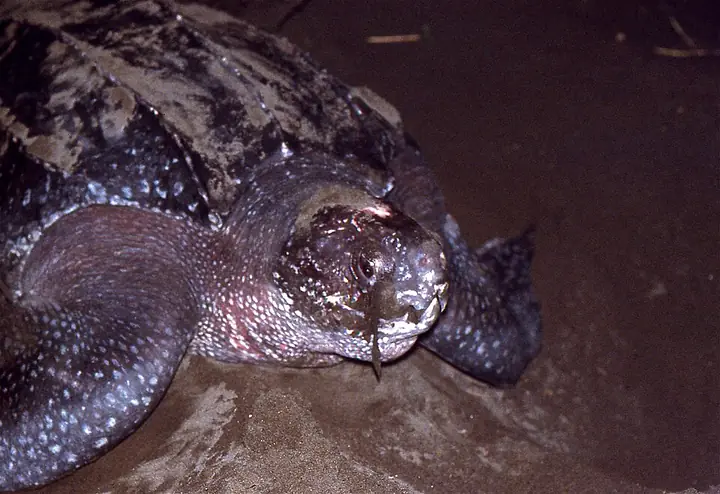
Davao Occidental's coast faces the Celebes Sea and the mouth of the Davao Gulf, with beaches that sea turtles still use for nesting. In July 2026 the DENR documented a leatherback, the world's largest sea turtle, laying eggs on the shore of Barangay Kiobog in Don Marcelino, and barangay officials stepped up monitoring of the nest.

A leatherback sea turtle on a nesting beach at night (photographed in Costa Rica)
Photo: Bernard DUPONT from FRANCE · CC BY-SA 2.0 · Wikimedia Commons
Leatherback Sea Turtle
Dermochelys coriacea
Critically Endangered (Philippine list)
The largest living turtle, with a soft, leathery shell instead of hard plates. Globally the IUCN lists it as Vulnerable, while the Philippine national list (DAO 2019-09) rates it Critically Endangered. The Don Marcelino turtle measured about 1.5 meters.
Field note: Keep lights and people away from nesting beaches at night, and report nests to the barangay or the DENR.
Meet all 65 Philippine animals in Hayop ng Pilipinas →

Republic Act 10360 was signed into law on January 14, 2013. It created Davao Occidental and made it the 81st province of the Philippines. In the municipalities of Don Marcelino, Jose Abad Santos, Malita, Santa Maria, and Sarangani, people celebrated. A new province meant a new government, new budget allocations, new attention from Manila.

What it also meant, practically, was that a provincial capitol had to be built, a governor had to be elected, an entire bureaucracy had to be assembled from scratch in a region where roads to the capital sometimes washed out in the rainy season. The first years of Davao Occidental were an exercise in institution-building under frontier conditions.

For the Tagakaulo communities along the coast, provinchood was a political event happening somewhat parallel to their own lives. Their concern was the status of their ancestral domain claims, which had been lodged with the National Commission on Indigenous Peoples and proceeded according to a different timeline from the provincial government's construction projects. A new province did not automatically resolve those claims. It created new interlocutors — a governor's office closer than Digos — but the fundamental negotiations remained unfinished.

The beaches of Davao Occidental's Celebes Sea and Davao Gulf coasts remain largely unknown outside the region. That will not last — the combination of relative remoteness, undeveloped shoreline, and existing marine biodiversity follows a pattern that has drawn developers to other parts of Mindanao. Whether the province manages that pressure better than its neighbors is an open question, and one that its young institutions are not yet fully equipped to answer.

Sources · updated 4 October 2026
Photo credits (2)

Photos from Wikimedia Commons, used under the licences shown; some were resized. All photo credits