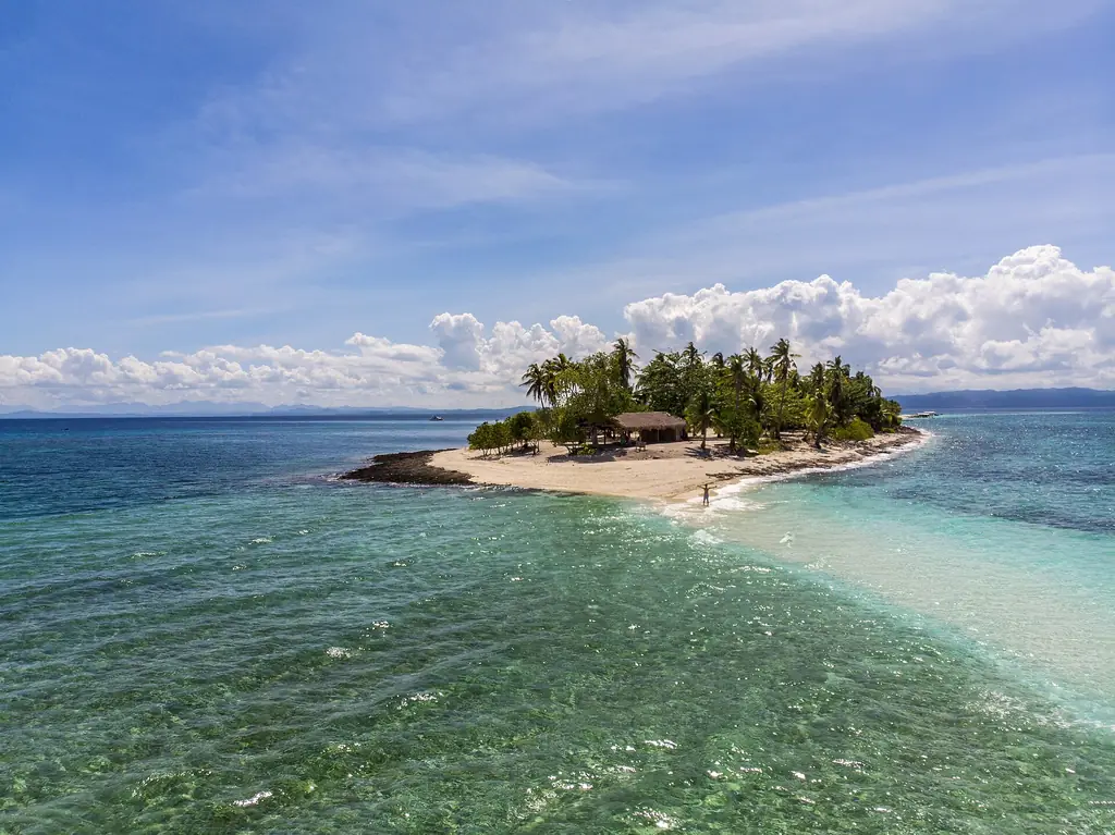
White sandbar of Kalanggaman Island, Palompon, Leyte
Photo: Gcabig2024 · CC BY-SA 4.0 · Wikimedia Commons
Map

Leyte

Eastern Visayas
Visayas
Capital Tacloban City
Population (2024) 2,082,811
Area 6,515 km²
Municipalities 40
Cities 3
Island Group Visayas
Languages Waray, Cebuano

Population: 2024 census (PSA). Area: land area. Population, area and city count include Ormoc and Tacloban, which the census lists separately from the province.

Kapitbahay — Neighboring Provinces

Leyte is a province in the Eastern Visayas region that occupies the northern three-quarters of Leyte Island, which it shares with Southern Leyte. Tacloban City is its capital and the regional center. Leyte is known in Philippine and American military history as the site of MacArthur's return landing at Palo Beach in 1944, and more recently as the province hardest hit by Typhoon Yolanda (Haiyan) in November 2013.

Tacloban CityCapital
6,515 km²Area
40Municipalities
3 (Tacloban, Ormoc, Baybay)Cities
VisayasIsland Group
Eastern Visayas (VIII)Region

The province faces the San Juanico Strait to the east, separating it from Samar island. The San Juanico Bridge, one of the longest in the Philippines, connects Leyte and Samar. The western coast faces the Camotes Sea and Visayan Sea. The interior is mountainous, with coastal plains around Tacloban and Ormoc supporting dense populations.

★
Leyte Gulf: Largest Naval Battle in History

The Battle of Leyte Gulf in October 1944 involved over 200,000 naval personnel, making it the largest naval battle of World War II and, by some criteria, the largest in history. MacArthur's ground forces waded ashore at Palo Beach on October 20, fulfilling the promise he made when he left the Philippines two years earlier.

Waray is the main language of Leyte, and the province's cultural identity is closely tied to the broader Waray-Waray tradition that spans Leyte and Samar. The economy is primarily agricultural — coconut, rice, and corn — with fishing significant along the coasts. Tacloban City functions as the commercial hub for the entire Eastern Visayas region.

The 2024 census counted 1,823,458 people in the province of Leyte, in 40 municipalities and the cities of Ormoc and Baybay. Tacloban, the capital and largest city, is a highly urbanized city that governs itself independently of the province; with its 259,353 people the total is 2,082,811. Ormoc, with 238,545 people, is an independent component city. The province takes up the northern three-quarters of Leyte Island, with Southern Leyte occupying the rest; Biliran, once a sub-province, became a separate province in 1992. Waray is spoken in the east and north, and Cebuano predominates in the western towns from Ormoc and Baybay to Palompon and Hilongos.
Leyte was among the earliest Visayan islands encountered by European explorers. Ferdinand Magellan's expedition reached Leyte waters in 1521, and the island was absorbed into the Spanish colonial system by the late 16th century. The province participated in the 1898 Philippine Revolution and then endured American pacification campaigns in the early 1900s.

1543

Villalobos Names the Islands

The Spanish explorer Ruy López de Villalobos reached the island in 1543 and named it Las Islas Felipinas, after the future Philip II, a name later given to the whole archipelago. Under Spanish rule Leyte and Samar were governed from Cebu.

1595–1597

Jesuit Missions

Jesuit missionaries set up a mission at Carigara in 1595, followed by Palo in 1596 and Ormoc and Alangalang in 1597. Leyte and Samar were separated from Cebu in 1735.

1959–1992

Leyte Divided

Biliran became a sub-province of Leyte on 8 April 1959, and on 22 May 1959 Republic Act No. 2227 made the southern part of the island the separate province of Southern Leyte. Biliran became a full province in 1992.

20 October 1944

MacArthur Returns

After four hours of naval bombardment, U.S. Sixth Army troops landed on the east coast of Leyte, and General Douglas MacArthur waded ashore at Red Beach in Palo with President Sergio Osmeña, beginning the liberation of the Philippines. Filipino guerrillas under Ruperto Kangleón fought alongside them.

23–26 October 1944

Battle of Leyte Gulf

The Japanese navy sent four forces against the landing, and four main engagements followed in the Sibuyan Sea, Surigao Strait, off Cape Engaño and off Samar. With over 200,000 naval personnel involved, it was the largest naval battle of World War II and, by some criteria, the largest in history. Organized Japanese resistance on Leyte ended in December.

8 November 2013

Typhoon Yolanda

After its first landfall at Guiuan, Typhoon Yolanda (Haiyan) struck Tolosa, Leyte, as an exceptionally powerful storm. A 5.2-meter storm surge destroyed the terminal of Tacloban Airport up to the second story, and the city administrator estimated that about 90 percent of Tacloban was destroyed. About 6,300 people died in the Philippines.

The recovery from Yolanda took years. Tacloban's coastal districts, flattened by the storm surge, were rebuilt — some in the same locations, some relocated inland per government resettlement plans. The city today shows the mix of new construction, repaired structures, and still-vacant lots that characterizes disaster recovery at this scale.

The Waray people of Leyte and Samar have a reputation throughout the Philippines as fierce, proud, and fiercely loyal to their own. The name Waray comes from waray, the word for 'none' or 'nothing', and the 1950s song "Waray-Waray" spread the image of Waray women who fear no one. This self-image was tested and reinforced by Yolanda's devastation and the community's rebuilding.

The Pintados

Spanish colonizers called the Visayan peoples 'Pintados' — the painted ones — for the extensive tattoo traditions they observed. Leyte's pre-colonial inhabitants tattooed their bodies as markers of status, courage, and spiritual protection. The tradition faded under Spanish colonial rule, but it has been studied by historians and is a source of cultural pride in the Eastern Visayas.

★
Imelda Marcos was from Tacloban

Imelda Romualdez was born in Manila in 1929 to Vicente Orestes Romualdez, a lawyer from a prominent Tacloban family. In 1938 her father moved the family back to Tacloban, where she grew up speaking Waray before learning Tagalog and English. She married Ferdinand Marcos in 1954 and was First Lady from 1965 to 1986.

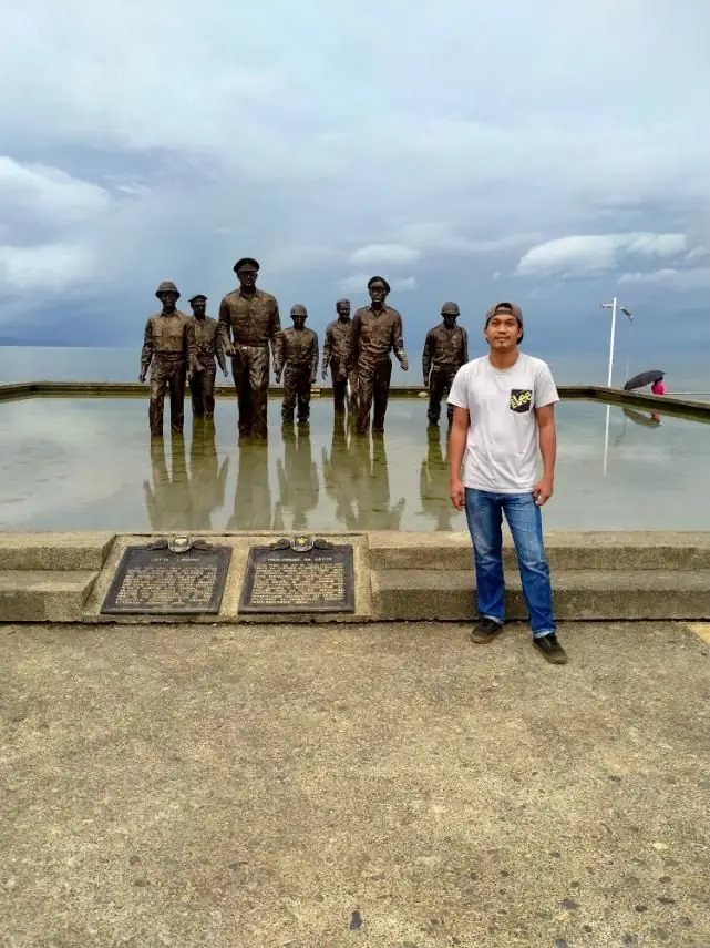
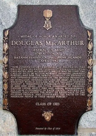
The MacArthur Landing Memorial in Palo is a central site of historical memory in Leyte. Seven larger-than-life bronze statues of MacArthur, President Osmeña and the party that waded ashore with them stand in a pool at Red Beach. Each year on October 20, the anniversary of the landing is commemorated there. The landing is woven into Leyte's civic identity.

See the great festivals in Pista ng Pilipinas →

Leyte's food reflects Visayan coastal cooking with Eastern influences from Samar and the Pacific-facing shores. Coconut is ubiquitous — in curries, stews, desserts, and vinegar. Fish from the Visayan Sea, Leyte Gulf, and inland fishponds are the protein staple. Waray cooking tends toward stronger flavors and larger portions compared to Cebuano cooking.

Binagol

A Waray specialty of Leyte and Samar: mashed giant taro (talyan) mixed with coconut milk, condensed milk, sugar and egg yolks, packed into half a coconut shell (bagol), wrapped in banana leaves and steamed. The result is dense and sweet. Binagol is a popular pasalubong (take-home gift) from Leyte.

Moron

A Waray rice cake from the area around Tacloban: glutinous rice cooked with coconut milk and sugar, swirled with chocolate and rolled in banana leaves, usually sold in bundles of four. Similar to suman but distinct in its chocolate swirl, it is a favorite pasalubong from Leyte.

Tinola na Isda (Waray Style)

Leyte / Eastern Visayas
10 minutesPrep
25 minutesCook
4Serves
Ingredients
  • 1 kg, cleaned and cut into piecesWhole fish (lapu-lapu or tilapia)
  • 2-inch piece, sliced thinGinger
  • 1 medium, slicedOnion
  • 2 medium, quarteredTomato
  • 1/2 small, cubedGreen papaya
  • 1 cupChili leaves or malunggay
  • 2 tbspFish sauce
  • 4 cupsWater
  • 2 stalks, bruisedLemongrass
Method
  1. Bring water to a boil. Add ginger, onion, tomato, and lemongrass. Simmer 5 minutes.
  2. Add papaya and cook for 5 minutes until slightly tender.
  3. Add fish pieces. Season with fish sauce. Cook for 8–10 minutes until fish is cooked through.
  4. Add chili leaves or malunggay in the last 2 minutes.
  5. Taste and adjust seasoning. Serve hot.
Cook's note

The Waray version of fish tinola uses lemongrass and is lighter than the chicken version. The broth should be clear and clean-tasting. Do not overcook the fish.

Waray (also called Waray-Waray or Lineyte-Samarnon) is the primary language of Leyte and Samar. It is an Austronesian language in the Bisayan branch, related to Cebuano and Hiligaynon but distinct enough that speakers of those languages require separate learning. Waray is one of the major regional languages of the Philippines.

Waray (east, north), Cebuano (west)Main languages
3.6 million native (2015, all regions)Waray speakers
Austronesian, BisayanFamily
Filipino, EnglishAlso

Cebuano is the main language of western Leyte, from Ormoc and Baybay to Palompon and Hilongos, where many people also speak Waray as a second language; Waray speakers call Cebuanos Kana, after their often-heard word kana, 'that'. Filipino and English are used in education, government, and commerce throughout the province.

★
Waray Literature

Waray has a notable tradition of poetry and folk literature. Spanish missionaries recorded the language early: Domingo Ezguerra's grammar, Arte de la lengua bisaya de la provincia de Leyte, appeared in 1663 and was reprinted in 1747. Contemporary Waray writers have produced fiction and poetry in the language, though it lacks the institutional support of Filipino and English.

The disaster of Yolanda generated a large literature in English and Filipino about the experience of Tacloban and Leyte — journalism, memoir, poetry.

Tacloban City is served by a domestic airport with regular flights from Manila and Cebu. Ormoc and other ports have ferries to Cebu and other Visayan islands. The San Juanico Bridge, part of the Pan-Philippine Highway, links Leyte to Samar, and from there roads and a ferry crossing lead north to Luzon, though the journey is long.

Daniel Z. Romualdez Airport, TaclobanAirport
~1.5 hoursFlight from Manila
~45 minutesFlight from Cebu
March to October (drier)Best Season

MacArthur Landing Memorial, Palo

Bronze statues of General MacArthur and his party mark the exact beach where the liberation of the Philippines began on October 20, 1944. The site is maintained as the MacArthur Landing Memorial National Park. The beach at Red Beach is quiet and accessible; the monument is one of the most historically significant landmarks in the Philippines.

Tacloban City

The capital city and regional center of Eastern Visayas. The city has been substantially rebuilt since Yolanda in 2013. The central market, the old colonial district, the Leyte Park waterfront, and the Santo Niño Church are the main points of interest. The Yolanda experience is documented at several community memorials.

San Juanico Bridge

At 2.16 kilometers, long the country's longest bridge and now the third longest over seawater, spanning the San Juanico Strait between Tacloban and Santa Rita, Samar. It was built from 1969 to 1973, during the Marcos administration, and was first called the Marcos Bridge. The views from the bridge across the strait — narrow, swift-flowing, lined with mangroves — are among the best in the Eastern Visayas.

Lake Danao, Ormoc

A guitar-shaped lake of volcanic origin in the forested hills 18 kilometers northeast of Ormoc, about half an hour's drive away. The 148-hectare lake lies within the 2,193-hectare Lake Danao Natural Park, which also takes in the Amandiwin Mountains. It was first named Lake Imelda when it became a national park in 1972.

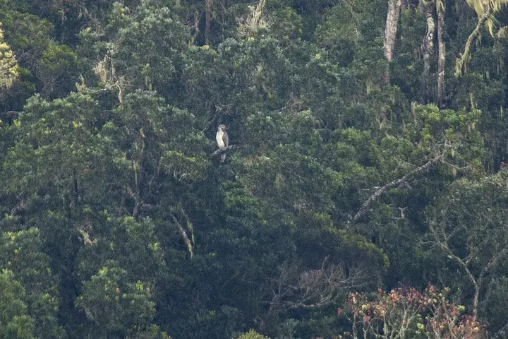
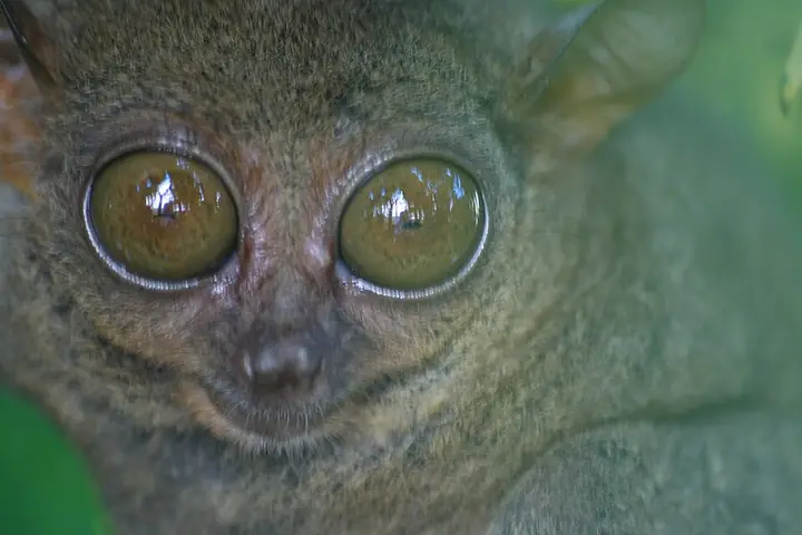
Leyte's mountainous spine still holds pockets of forest. The best known is the Lake Danao Natural Park in the uplands northeast of Ormoc: its guitar-shaped lake of volcanic origin covers 148 hectares within a 2,193-hectare park that includes the Amandiwin Mountains. It was declared a national park in 1972, as Lake Imelda, and renamed Lake Danao National Park in 1998 under Proclamation No. 1155; it is now protected under the National Integrated Protected Areas System. Studies of its birds found that hunting, mostly of hornbills, doves and pigeons and often by outsiders, is the main threat, along with slash-and-burn farming and illegal logging. The island's forests are also home to the Philippine tarsier, and the Philippine eagle, whose last Leyte records came before Typhoon Yolanda, is the focus of a reintroduction project.

A Philippine eagle in the wild (photographed in Mindanao)
Photo: Francesco Veronesi from Italy · CC BY-SA 2.0 · Wikimedia Commons
Philippine Eagle
Pithecophaga jefferyi
Critically Endangered
The national bird, found only on Luzon, Samar, Leyte and Mindanao. Leyte had perhaps two breeding pairs, with no sightings after Typhoon Yolanda in 2013; in June 2024 two rescued eagles from Mindanao were released on the island in a reintroduction attempt.
Field note: Report sightings to the Philippine Eagle Foundation or the DENR; killing an eagle is punishable by up to 12 years in prison.
A Philippine tarsier (photographed in Bohol)
Photo: John Martin PERRY · CC BY-SA 4.0 · Wikimedia Commons
Philippine Tarsier
Carlito syrichta
Near Threatened
A palm-sized nocturnal primate with huge eyes. The subspecies Carlito syrichta syrichta lives on Leyte and Samar, and habitat loss and poaching for the pet trade are its main threats.
Field note: Never buy or keep a tarsier; watch them only at licensed sanctuaries.
Meet all 65 Philippine animals in Hayop ng Pilipinas →
← All stories
Kasaysayan · Palo

The MacArthur Landing Memorial

On 20 October 1944, General Douglas MacArthur waded ashore at Red Beach in Palo, Leyte, making good on his promise, I shall return. The Leyte Landing began the liberation of the Philippines from Japanese occupation.

The moment is marked today by the MacArthur Landing Memorial National Park in Palo, a short drive from Tacloban. Seven bronze statues, larger than life, stand in a pool of water, re-enacting that famous stride onto the shore.

The statues are more than ten feet tall, and through storm after storm they have held their ground. To stand before them is to feel the weight of that day, and I told myself I would return here too, next time with my family.

Mga Larawan

The Eagles of Leyte

Leyte once had its own Philippine eagles, but only about two pairs were thought to survive, and after Typhoon Yolanda tore through the forests in 2013 there were no more sightings. In June 2024 the Philippine Eagle Foundation tried to bring them back: two rescued eagles from Mindanao, fitted with trackers, were released in Leyte in the hope that they would pair. The male, named Uswag, was later found dead at sea, probably blown off course by the wind. The female, Carlito, was still alive and hunting for herself in October 2024.

Sources · updated 4 October 2026
Photo credits (3)

Photos from Wikimedia Commons, used under the licences shown; some were resized. All photo credits