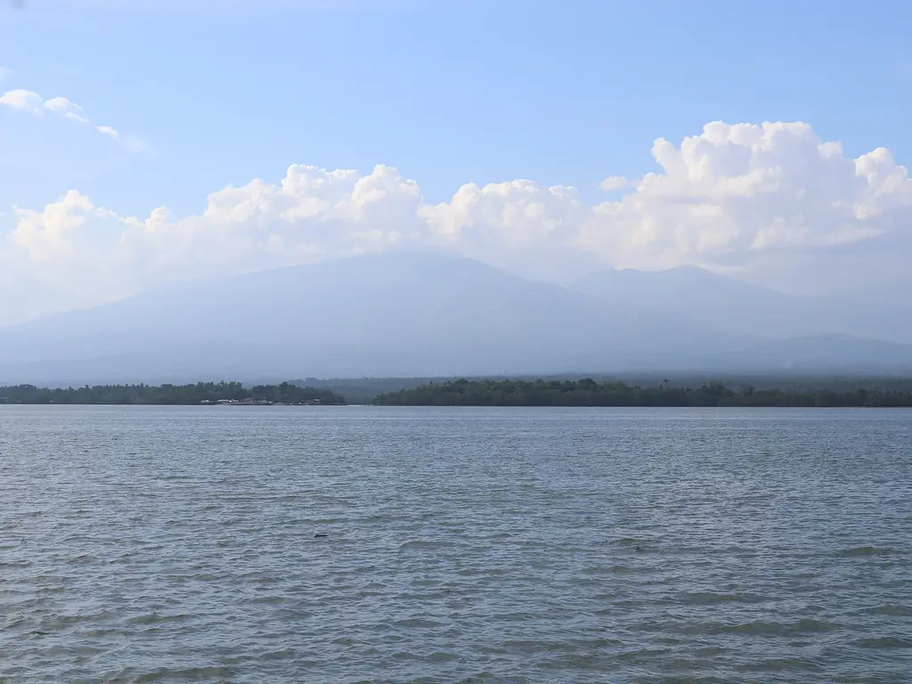
Panguil Bay at Tangub with Mount Malindang beyond
Photo: Patrickroque01 · CC BY-SA 4.0 · Wikimedia Commons
Map

Misamis Occidental

Northern Mindanao
Mindanao
Capital Oroquieta City
Population (2024) 621,993
Area 2,055 km²
Municipalities 14
Cities 3
Island Group Mindanao
Languages Cebuano, Subanen

Population: 2024 census (PSA). Area: land area.

Kapitbahay — Neighboring Provinces

Misamis Occidental is a coastal province in Northern Mindanao, bounded by the Bohol Sea to the northeast, Iligan Bay to the east and Panguil Bay to the southeast. It sits at the base of the Zamboanga Peninsula, making it the gateway between the Northern Mindanao heartland and the long finger of land that extends to Zamboanga City. Oroquieta City is the provincial capital. The province is largely agricultural, with coconut and corn as the main crops.

Oroquieta CityCapital
2,055 km²Area
14 + 3 citiesMunicipalities
MindanaoIsland Group
Northern Mindanao (X)Region

Panguil Bay is the defining geographic feature of the province's southern coast — a deeply indented bay shared with Lanao del Norte across the water. The bay has historically been important for inter-island fishing and coastal trade. Since September 2024 the Panguil Bay Bridge has linked Misamis Occidental directly across the bay to Lanao del Norte.

★
Panguil Bay Bridge

The Panguil Bay Bridge, opened in September 2024, connects Tangub City in Misamis Occidental to Tubod in Lanao del Norte. At 3.77 kilometers it is the longest bridge over water in Mindanao, and it cut a 2.5-hour drive around the bay to a few minutes.

The province has a mixed cultural makeup reflecting its position at the crossroads of Northern Mindanao. Cebuano is the dominant language of the lowland majority, while indigenous Subanen communities live in the upland areas. Maranao and other minority communities speak their own languages alongside Cebuano.

The 2024 census counted 621,993 people in Misamis Occidental's 14 municipalities and three cities, Oroquieta, Ozamiz and Tangub. Oroquieta is the capital, while Ozamiz is the most populous city. The province borders Zamboanga del Norte and Zamboanga del Sur to the west and is separated from Lanao del Norte by Panguil Bay to the south and Iligan Bay to the east. Its name is believed to come from kuyamis, a Subanen word for a variety of coconut.
The area was first settled by the Subanen, followed by the Maranao and later by Visayans, who settled the coasts. The Spanish built a fort at Misamis, at the mouth of Panguil Bay, in 1756, and the old province of Misamis was split into its western and eastern halves in 1930.

1756

Fort at the Mouth of Panguil Bay

After a flotilla under the Jesuit José Ducos defeated raiders in the area, the Spanish built a stone fort, the Fuerte de la Concepción y del Triunfo, known locally as the Cotta, at a place called Misamis at the mouth of Panguil Bay.

1929–1930

Province Created

Act No. 3537 of 2 November 1929 divided the old province of Misamis into Misamis Occidental and Misamis Oriental, effective 1 January 1930. José Ozámiz became the first governor, and on 6 January 1930 the provincial council chose Oroquieta as the capital.

1942–1945

Capital of the Free Philippines

The Japanese landed on 6 May 1942. During the war, Oroquieta became the capital of the "Free Philippines" under the guerrilla forces of Colonel Wendell Fertig, and the town issued emergency notes. On learning this, President Quezon authorized the printing of the Mindanao emergency note.

1948

Ozamiz Becomes a City

The town of Misamis became the chartered City of Ozamiz under Republic Act No. 321 in 1948.

1969–1970

Oroquieta Becomes a City

Republic Act No. 5518, signed on 25 June 1969, made Oroquieta a city, and it was inaugurated as a chartered city on 1 January 1970.

2024

Panguil Bay Bridge Opens

The 3.77-kilometer Panguil Bay Bridge between Tangub and Tubod, Lanao del Norte, opened in September 2024. It is the longest bridge over water in Mindanao and cut a 2.5-hour drive around the bay to a few minutes.

Through the late twentieth century, Misamis Occidental's position at the gateway to the Zamboanga Peninsula made it a transit zone between the peninsula and the Northern Mindanao heartland, and the province itself remained largely peaceful.

Misamis Occidental's culture is predominantly lowland Cebuano Catholic, shaped by centuries of Visayan migration and the Catholic mission tradition. Fiesta culture centers on patron saints' feasts with processions, street fairs, and family gatherings. In January, Ozamiz and other towns welcome a pilgrim image of the Santo Niño from Cebu during their Sinulog celebrations.

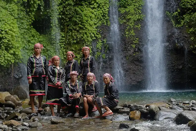
The Subanen

Subanen men and women of Mount Malindang at a waterfall
Photo: Theglennpalacio · CC BY-SA 4.0 · Wikimedia Commons

The Subanen (also spelled Subanon or Subano) are one of the largest indigenous groups in Mindanao. Their name means "people of the river", reflecting their traditional settlements along rivers in the interior. Subanen communities in Misamis Occidental maintain distinct ritual practices, agricultural traditions, and a social system centered on the timuay, the community leader who also settles disputes between families. They have faced land pressure from agricultural expansion for decades.

The uplands of the Malindang range are Subanen homeland. Inside Mount Malindang Range Natural Park, about 20,000 hectares are farmed and inhabited, mostly by Subanen communities, who keep their own leaders, the timuay, and their own language alongside Cebuano.

Ozamiz is the province's most populous city and its main port, and its old Spanish fort, the Cotta, still stands at the mouth of Panguil Bay. Tangub City is a fishing port on Panguil Bay famous for its seafood. Coconut is the main crop, processed into oil, desiccated coconut and coir, much of it shipped to Cebu.

See the great festivals in Pista ng Pilipinas →

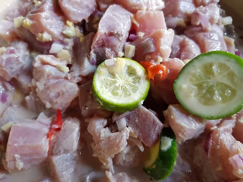
The food of Misamis Occidental is Cebuano lowland cooking with the abundant fresh fish of Panguil Bay and the Bohol Sea. Grilled fish, kinilaw, fish soups, and rice are the daily fare. Coconut — the province's main agricultural product — appears in cooking as gata (coconut milk) and as a source of cooking oil.

Kinilaw: raw fish in vinegar and citrus with cucumber and chili
Photo: Obsidian Soul · CC0 · Wikimedia Commons

Kinilaw na Isda

Raw fish cured in cane vinegar and mixed with ginger, onion, chili, and sometimes coconut cream. The freshest catch from Panguil Bay — yellowfin tuna, tanigue (mackerel), or local white fish — is used. The acid in the vinegar denatures the surface proteins without heat.

Inihaw na Pusit

Whole squid grilled over charcoal, stuffed with its own tentacles and a mixture of tomato, onion, and garlic. Dipped in vinegar with chili. A staple street food throughout coastal Mindanao.

Sinabawang Isda (Misamis Coastal Fish Soup)

Misamis Occidental
10 minutesPrep
20 minutesCook
4Serves
Ingredients
  • 1 kg, cleanedWhole fish (any firm white fish)
  • 3 medium, quarteredTomato
  • 1 medium, slicedOnion
  • 1-inch piece, sliced thinGinger
  • 3 tbsp tamarind paste or 6 pieces kamiasTamarind (or kamias for souring)
  • 2 tbspFish sauce
  • 4 cupsWater
  • 2 wholeLong green chili
  • 1 cup, loosely packedPechay or kangkong
Method
  1. Bring water to a boil. Add tomato, onion, and ginger.
  2. Add tamarind paste or kamias. Simmer 5 minutes.
  3. Add whole fish and long green chili. Season with fish sauce.
  4. Cook 10–12 minutes until fish is cooked through.
  5. Add greens in the last 2 minutes.
  6. Serve hot. The broth should be sour, salty, and clear.
Cook's note

Use the freshest fish you can get — this soup is transparent about quality. Kamias (bilimbi) gives a sharper, more fragrant sourness than tamarind. If both are available, use kamias.

Cebuano is the dominant language of Misamis Occidental's lowland population, brought by Visayan migrants from Cebu, Bohol, and the Eastern Visayas over several centuries of settlement. It is the language of the market, the street, and most everyday interaction in urban and coastal communities.

CebuanoLingua franca
SubanenIndigenous
MaranaoAlso
Filipino, EnglishOfficial

Subanen languages are spoken by indigenous communities in the province's interior municipalities. Subanen belongs to the Philippine language family but is not closely related to Cebuano, and the two communities communicate through Filipino or through Cebuano, which Subanen people often learn as a second language.

★
Subanen Language Family

The Subanen languages form their own branch of the Philippine language family, distinct from both the Visayan and Maguindanaon branches. Several varieties of Subanen are spoken across the Zamboanga Peninsula and the western parts of Northern Mindanao, and linguists classify some of these as separate languages rather than dialects.

Filipino and English are used in schools and government offices. Oroquieta City, as a regional center, also has a Spanish-language heritage visible in family names and some church records from the colonial period.

Misamis Occidental is accessible by road from Cagayan de Oro City, about three hours west along the national highway. Ozamiz City, the province's main port, has ferry and cargo links, and since 2024 the Panguil Bay Bridge has made the trip from Lanao del Norte much shorter.

Laguindingan (CDO), ~100 km eastNearest Airport
~2.5–3 hours by roadFrom CDO
Ozamiz CityMain Port
Panguil Bay, Subanen culture, coastal seafoodMain Draw

Panguil Bay

The large bay forming the southern boundary of the province. The bay is important for fishing and marine transport, and since 2024 the Panguil Bay Bridge has spanned it between Tangub and Tubod. Ozamiz sits on its narrowest part, and the Cotta fort guards its mouth.

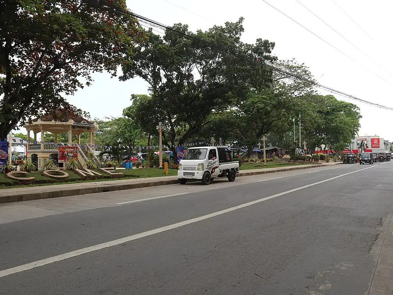
The city plaza along Rizal Street, Oroquieta
Photo: Patrickroque01 · CC BY-SA 4.0 · Wikimedia Commons

Oroquieta City

The provincial capital, a compact city with a laid-back character compared to the larger Northern Mindanao hubs. Its old provincial capitol served as the seat of the guerrilla "Free Philippines" government during World War II. The city faces Iligan Bay. The city is a practical base for exploring the province.

Sapang Dalaga

A municipality in the interior of the province, known for its agricultural landscape and proximity to Subanen communities in the hills. A quiet stop on road journeys through the province's interior.

Piduan Falls in the forest of Mount Malindang
Photo: Theglennpalacio · CC BY-SA 4.0 · Wikimedia Commons

Mount Malindang Range Natural Park

The 53,262-hectare park covers the Malindang range, which rises to about 2,404 meters on the border of Misamis Occidental and the Zamboanga provinces. It has waterfalls, a crater lake and some of the largest remaining forest in the region, and it is home to Subanen communities. Visits need permits and local guides.

Mount Malindang, about 2,404 meters high, rises over the west of the province. Mount Malindang Range Natural Park, first declared a national park in 1971 and made a natural park in 2002, covers 53,262 hectares in Misamis Occidental, Zamboanga del Sur and Zamboanga del Norte. About 62% of it is still forested, and around 20,000 hectares are farmed and inhabited, mostly by Subanen communities. The range has waterfalls, a crater lake and forest that shelters tarsiers, flying lemurs, Philippine deer, Philippine warty pigs, rufous hornbills and the Philippine eagle. Panguil Bay, on the other side of the province, is a rich fishing ground.

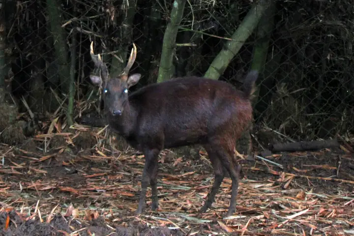
A male Philippine deer (photographed near Davao)
Photo: Gregg Yan · CC BY-SA 3.0 · Wikimedia Commons
Philippine Deer
Rusa marianna
Vulnerable
A small brown deer that lives in the forests of the Philippines, including the Malindang range. Hunting and forest loss have reduced its numbers.
Field note: Do not buy wild deer meat; hunting is illegal in protected areas.
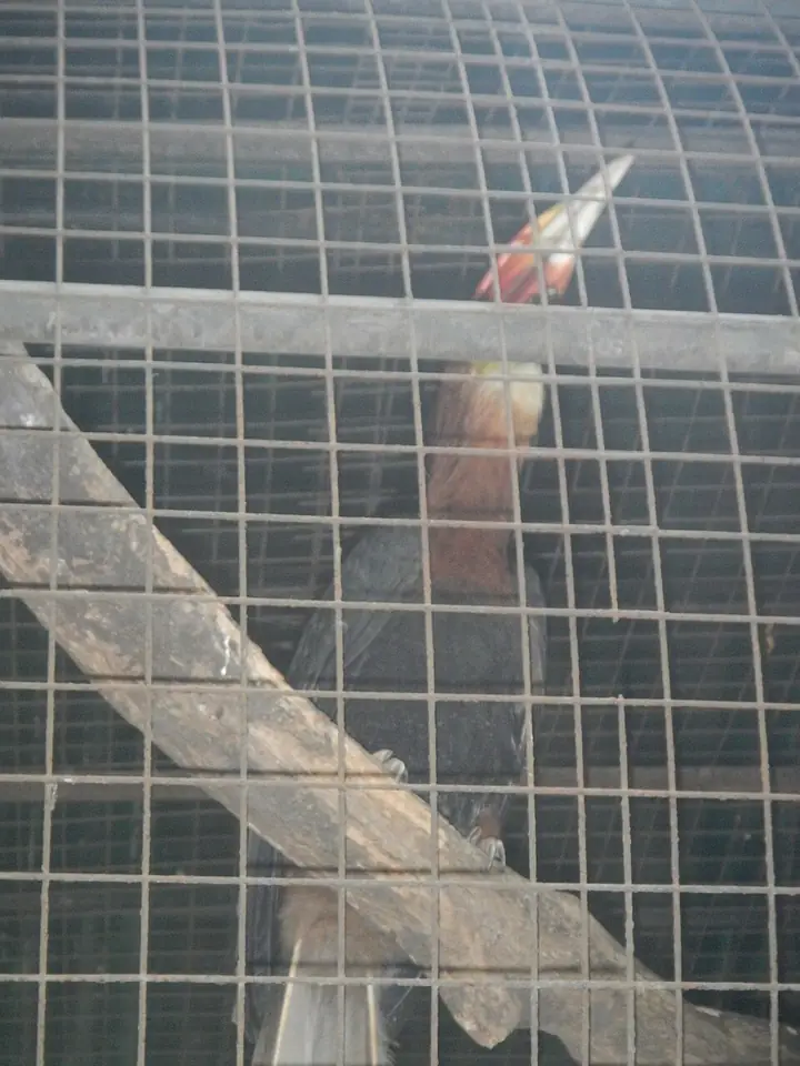
A rufous hornbill (photographed at Ninoy Aquino Parks & Wildlife Center, Quezon City)
Photo: Ramon FVelasquez · CC BY-SA 3.0 · Wikimedia Commons
Rufous Hornbill
Buceros hydrocorax
Vulnerable
A large hornbill with a red bill, known locally by names such as kalaw. It needs big old trees for nesting and is recorded on Mount Malindang.
Field note: Protect large nesting trees and never take hornbill chicks.
Meet all 65 Philippine animals in Hayop ng Pilipinas →

Crossing the Bay

Panguil Bay is not large by ocean standards, but it is wide enough that a crossing requires a boat and takes long enough to make you feel the distance. For most of the province's history, the bay has been the practical boundary between Misamis Occidental and Lanao del Norte — two provinces that look at each other across the water but belong to different worlds.

The fishermen of the Misamis Occidental shore have worked the bay for generations. They know its currents, the areas where the fish run deepest, the weather that comes in off the surrounding mountains. The bay is productive — the convergence of fresh river water from the surrounding highlands and the salt water of the Bohol Sea creates the kind of nutrient mixing that supports fish stocks. When the catch is good, the Oroquieta market fills before dawn.

The bridge has changed things. Since September 2024, the 3.77-kilometer Panguil Bay Bridge has cut the trip from Tangub to Tubod from about two and a half hours around the bay to a few minutes. Land around both ends of the bridge is already changing. What happens to the fishermen and the small boats that were the only way across for centuries is still being worked out.

Sources · updated 4 October 2026
Photo credits (7)

Photos from Wikimedia Commons, used under the licences shown; some were resized. All photo credits