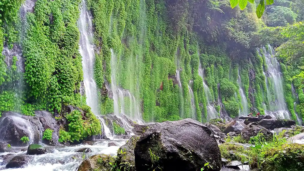
The curtain of Asik-Asik Falls, Alamada, Cotabato
Photo: Jyppe A. Quidores · CC BY-SA 4.0 · Wikimedia Commons
Map

Cotabato

SOCCSKSARGEN
Mindanao
Capital Kidapawan City
Population (2024) 1,286,142
Area 9,009 km²
Municipalities 17
Cities 1
Island Group Mindanao
Languages Maguindanaon, Hiligaynon, Cebuano

Population: 2024 census (PSA). Area: land area. Population excludes the eight Special Geographic Area municipalities, which belong to BARMM and are counted separately in the 2024 census (214,703 people). The area is the province’s official land area, which still includes them.

Kapitbahay — Neighboring Provinces

Cotabato is a landlocked province in the SOCCSKSARGEN region of central Mindanao. At about 9,009 square kilometers it is one of the larger provinces in the Philippines and one of the most agriculturally productive, producing substantial portions of the national output of rice, corn, and other crops. It borders Lanao del Sur and Bukidnon to the north, Davao del Norte and Davao City to the east, Davao del Sur to the southeast, Sultan Kudarat to the south, and Maguindanao del Norte and Maguindanao del Sur to the west. Mount Apo — the highest peak in the Philippines — rises on its eastern boundary.

Kidapawan CityCapital
9,009 km²Area
17 + 1 cityMunicipalities
MindanaoIsland Group
SOCCSKSARGEN (XII)Region

The province occupies the upper Cotabato Basin — the fertile river plains of the Mindanao River system. It stretches from Mount Apo in the east to the Piapayungan Range in the west, and between them lies the basin of the Pulangi River, or Rio Grande de Mindanao, the second-longest river in the Philippines at about 373 kilometers. Settlement by Christian migrants from Luzon and the Visayas during the American period and postwar resettlement programs transformed what was once predominantly Maguindanao and Lumad territory into a mixed-population province.

★
One of the Largest Provinces

Cotabato covers about 9,009 km², and the old province of Cotabato, before it was divided, was once the largest in the Philippines. Its size reflects the Cotabato Basin's geographic scope — a broad, flat river plain surrounded by mountain ranges on three sides.

Kidapawan City sits at the base of Mount Apo, the highest mountain in the Philippines at 2,954 meters. The mountain is a protected natural park and the most prominent feature of the province's skyline. Its slopes hold mossy and montane forest, and at Ilomavis in Kidapawan the Mindanao Geothermal Production Field supplies power to the city and neighboring provinces.

The 2024 census counted 1,286,142 people in the province's 17 municipalities and its one city, Kidapawan. Eight further municipalities created from 63 barangays that voted in 2019 to join Bangsamoro lie inside the province's borders, but they are governed by BARMM as its Special Geographic Area. Cotabato is one of the few Philippine provinces that typhoons do not pass through, and rain falls fairly evenly through the year.
Cotabato's pre-colonial history is the history of the Cotabato Basin peoples — Maguindanao, B'laan, Tiruray, and other Lumad groups who inhabited the river plains and surrounding highlands. The Maguindanao sultanate's influence extended into the basin. Spanish penetration of the interior was limited; the Cotabato area remained largely under indigenous and sultanate authority.

1619

Seat of the Maguindanao Sultanate

Islam reached the Maguindanao in the late 15th century through Sharif Muhammad Kabungsuan. Cotabato became the capital of the Maguindanao Sultanate, and in 1619 it became the seat of power of Sultan Muhammad Kudarat.

1860

Spanish District of Cotabato

The Spanish could not push into the region until the second half of the 19th century. In 1860 they formed the district of Cotabato, with its capital at Tamontaka, and in 1893 they built Fort Pikit, the site of one of the province's oldest towns.

1903

District of the Moro Province

Act No. 787 of the Philippine Commission created the Moro Province on 15 July 1903, and Cotabato, which then also covered today's Maguindanao, Sultan Kudarat, South Cotabato and Sarangani, became one of its districts. The first Visayan settlers reached Pikit in 1913.

1950s–1960s

Postwar Settlement

Settlement from Luzon and the Visayas sped up after the war, and the old province of Cotabato, once the largest in the Philippines, began to be divided; South Cotabato separated in 1966.

1971

Manili Massacre

On 19 June 1971, at least 70 Moro residents, including women and children, were killed in a mosque in Manili, Carmen, where they had gathered for supposed peace talks. Armed men suspected to belong to the Ilaga militia opened fire.

1973

North Cotabato Created

Presidential Decree No. 341 of 22 November 1973 divided what remained of old Cotabato into North Cotabato, Maguindanao and Sultan Kudarat. Batas Pambansa Blg. 660, approved on 7 March 1984, renamed North Cotabato as Cotabato.

1998

Kidapawan Chartered as a City

Republic Act No. 8500, signed on 12 February 1998, made Kidapawan a component city. It had become a municipality on 18 August 1947, a date the city still celebrates every year.

2019

Bangsamoro Plebiscite

In the February 2019 plebiscite, 63 mostly Muslim barangays in the western municipalities voted to join the new Bangsamoro region. They now form eight municipalities in BARMM's Special Geographic Area.

Cotabato has a diverse population reflecting its history as a settler province. About 71% of the people descend from settlers from the Visayas and Luzon, the largest group of them Hiligaynon-speaking. The rest include Maguindanaon, Iranun, Ilianen, Dulangan Manobo, Obo, Tagabawa and T'boli communities. In the 2020 census about 53% of the people were Catholic and about 19% Muslim.

Lumad Peoples

The Obo, Tagabawa and other Manobo groups live mainly in the uplands around Mount Apo, on ancestral lands in the highlands. To them the mountain is sacred: its name comes from Apo Sandawa, "Grandfather Sandawa", the spirit of the mountain, and rituals to him are led by a shaman. Indigenous schools and community groups work to keep these practices alive.

★
Mount Apo Natural Park

Mount Apo Natural Park was set up under Republic Act No. 9237 and covers about 54,975 hectares in Cotabato and Davao. The highest peak in the Philippines is home to more than 270 bird species, among them the critically endangered Philippine eagle. The mountain is sacred to the Manobo and Kalagan peoples.

The province's lowland culture is shaped by its agricultural character. The rice harvest season structures the community calendar. Fiesta culture among Catholic communities follows the patron saints' feast schedule. The biggest civic event is Kidapawan's Timpupo fruit festival every August, held together with the city's foundation anniversary on 18 August.

See the great festivals in Pista ng Pilipinas →

Cotabato's food reflects its settler population — primarily Cebuano and Ilonggo cooking traditions, adapted to Mindanao ingredients and the agricultural abundance of the Cotabato Basin. The province produces corn, rice, coffee, banana, and vegetables in large quantities. Freshwater fish from the river system supplement the diet.

Corn Grits (Mais)

A staple carbohydrate in Cotabato and much of central Mindanao, boiled corn grits are eaten as a rice substitute or alongside rice. The province's large corn production makes it a natural part of the local diet, particularly in rural areas where corn farming is the primary livelihood.

Kilawin na Kambing

Goat meat prepared in the kinilaw style — boiled briefly, then mixed with vinegar, onion, ginger, and chili while still hot. A celebration dish common at gatherings in Cotabato's farming communities. The goat flavor is strong and the acid-heat balance is the cooking challenge.

Sinigang na Baboy sa Batwan (Pork Sinigang, Cotabato Style)

Cotabato
15 minutesPrep
1 hourCook
6Serves
Ingredients
  • 700g, cut into piecesPork ribs or belly
  • 8 pieces fresh, or 3 tbsp tamarind pasteBatwan fruit (or tamarind)
  • 1 medium, quarteredOnion
  • 2 medium, quarteredTomato
  • 1 medium, sliced into roundsRadish
  • 1 medium, slicedEggplant
  • 100g, cut into 2-inch piecesString beans
  • 1 cup loosely packedKangkong or spinach
  • 2 tbspFish sauce
  • 8 cupsWater
Method
  1. Bring water to boil with onion and tomato. Add pork and skim scum.
  2. Simmer pork for 40 minutes until tender.
  3. Add batwan or tamarind and radish. Cook 10 minutes.
  4. Add eggplant and string beans. Cook 5 minutes.
  5. Add kangkong and fish sauce. Cook 2 minutes more.
  6. Taste — adjust sourness with more batwan or tamarind. Serve hot.
Cook's note

Batwan is the preferred souring agent in the Cotabato-Visayas corridor. It has a distinctive fruity-sour flavor that tamarind approximates but does not match exactly. If you find batwan (available in Visayan wet markets), use it.

Hiligaynon is the most widely spoken language in Cotabato, used by about 46% of the people according to provincial figures. It came with Visayan settlers from Panay and Negros, who began arriving in 1913, and it is the everyday language of many lowland towns and markets.

Hiligaynon (~46%)Most spoken
Maguindanaon, Cebuano, IlocanoAlso
Obo and other Manobo languagesIndigenous
Filipino, EnglishOfficial

Maguindanaon (about 38%) is spoken mainly in the western municipalities bordering the Maguindanao provinces, Cebuano by about 8% and Ilocano by about 4%. B'laan, Tiruray, and various Manobo languages are spoken by indigenous communities in the upland areas. Filipino and English serve as the languages of education and government.

★
Multilingual Mindanao

Cotabato exemplifies the linguistic complexity of Mindanao settler provinces. A single municipality may have Hiligaynon- and Cebuano-speaking lowland farmers, Maguindanaon Muslim communities in certain barangays, B'laan indigenous villages in the hills, and Ilocano settlers who came in a separate migration wave — all within a few kilometers of each other. Filipino serves as the bridge language in this environment.

Ilocano is also spoken by communities of northern Luzon migrants who settled in Cotabato under the various Land Settlement Development Corporation (LASEDECO) programs of the postwar period. These communities have maintained Ilocano language and culture for generations alongside the Hiligaynon- and Cebuano-speaking majority.

Kidapawan City is the main access point for Cotabato. It is connected by national highway to General Santos City to the south (about 2 hours), to Davao City to the southeast (about 3 hours), and to Cotabato City to the west. There is no direct airport in the province; travelers use Francisco Bangoy International Airport in Davao or Cotabato (Awang) Airport in Datu Odin Sinsuat, next to Cotabato City.

Davao Airport (~3 hours) or Cotabato Airport (~2 hours)Nearest Airport
~3 hours by road to KidapawanFrom Davao
~2 hours to KidapawanFrom GenSan
Mount Apo, Lake Agco, Kidapawan CityMain Draw

Mount Apo Natural Park

The highest mountain in the Philippines at 2,954 meters. Mount Apo is a certified climb for experienced mountaineers with proper permits — the Kidapawan route takes about 3–4 days round trip. The mountain park has volcanic terrain, sulfur vents, crater lakes such as Lake Venado, and Philippine eagles.

Lake Agco

A lake once called "The Blue Lake", in Barangay Ilomavis, Kidapawan, at the foot of Mount Apo. The lake sits in a volcanic area with natural hot spring pools, bubbling mud, and a sulfuric smell that clears immediately when you enter the surrounding forest. The area is the main staging point for Mount Apo climbs from the Cotabato side.

Kidapawan City

The provincial capital, a quiet city with a functioning market, several restaurants serving Mindanao cooking, and a commercial strip serving the surrounding agricultural area. The Kidapawan City Botanical Garden and the Asik-Asik Falls in the municipality of Alamada are day-trip options from the city.

Asik-Asik Falls, Alamada

A curtain waterfall in Alamada municipality — water seeps through and falls from a wide flat cliff face covered in vegetation, creating a broad, dense cascade without a single stream source. The effect is unusual and makes Asik-Asik one of the more visually distinctive waterfalls in Mindanao.

Cotabato rises from the wide Pulangi River plain to Mount Apo, the highest mountain and volcano in the Philippines at 2,954 meters. Mount Apo Natural Park, set up under Republic Act No. 9237, protects about 54,975 hectares of forest on its slopes. The mountain is home to more than 270 bird species, 111 of them found only in the area, including the critically endangered Philippine eagle. Lake Agco and Lake Venado lie on its slopes, and the forests of central Mindanao also shelter shy ground birds such as the Mindanao bleeding-heart.

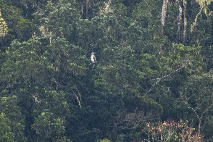
A Philippine eagle in the wild (photographed in Mindanao)
Photo: Francesco Veronesi from Italy · CC BY-SA 2.0 · Wikimedia Commons
Philippine Eagle
Pithecophaga jefferyi
Critically Endangered
The national bird and one of the world's largest eagles. Mount Apo is one of its best-known strongholds.
Field note: Report sightings and never disturb nests; killing the eagle is punishable by law.
Mindanao Bleeding-heart
Gallicolumba crinigera
Vulnerable
A ground dove with a red patch on its white breast that looks like a wound. It lives in the forests of Mindanao and nearby islands and is threatened by logging and hunting for food and the pet trade.
Field note: Hunting, capturing or keeping it is illegal under Republic Act No. 9147.
Meet all 65 Philippine animals in Hayop ng Pilipinas →

What the Mountain Holds

Mount Apo is not a mountain you summit casually. Its upper reaches — the mossy forest, the sulfuric crater, the boulder fields approaching the peak — require several days on the trail, proper gear, and a permit from the protected area management office. The mountain lies on the boundary between Cotabato and the Davao provinces, and both provincial governments maintain entrance points. The Kidapawan side, through Lake Agco, is the traditional route.

For the Manobo and Kalagan peoples whose ancestral territory includes the mountain's slopes, Apo is not a trekking destination but a presence. The mountain appears in creation stories. It holds the origins of rivers. It is the place where certain rituals must be performed at certain times. The national park boundary drawn by the government does not coincide with the boundaries the mountain's indigenous custodians would draw.

Climbers from Davao and Kidapawan reach the summit and take photographs with the flag. The Philippine Eagle nests somewhere in the forest below the treeline, rarely seen. The sulfuric vents at the crater's edge smell like the underside of creation. The mountain will be there when everyone who has ever photographed its peak is gone. That, at least, is what the people of Apo Sandawa have always known.

Sources · updated 4 October 2026
Photo credits (2)

Photos from Wikimedia Commons, used under the licences shown; some were resized. All photo credits